Jaca elevation
Jaca (Aragon, Provincia de Huesca), Spain elevation is 827 meters and Jaca elevation in feet is 2713 ft above sea level [src 1]. Jaca is a seat of a third-order administrative division (feature code) with elevation that is 224 meters (735 ft) bigger than average city elevation in Spain.
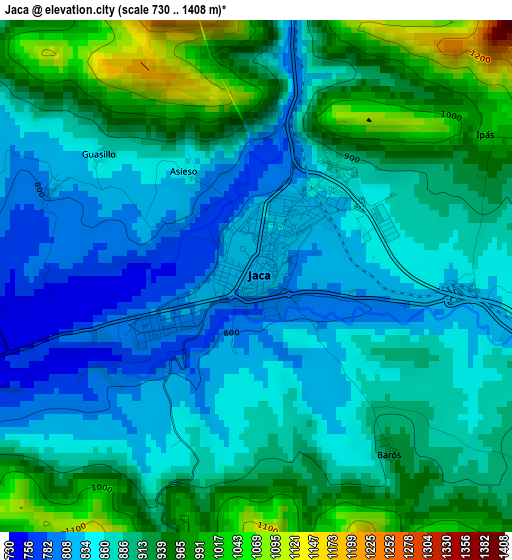
Below is the Elevation map of Jaca, which displays elevation range with different colors. Scale of the first map is from 730 to 1408 m (2395 to 4619 ft) with average elevation of 891.8 meters (=2926 ft) [note 1]
These maps also provides idea of topography and contour of this city, they are displayed at different zoom levels. More info about maps, scale and edge coordinates you can find below images.
| \ | Map #1 | Map #2 | Topo.Map |
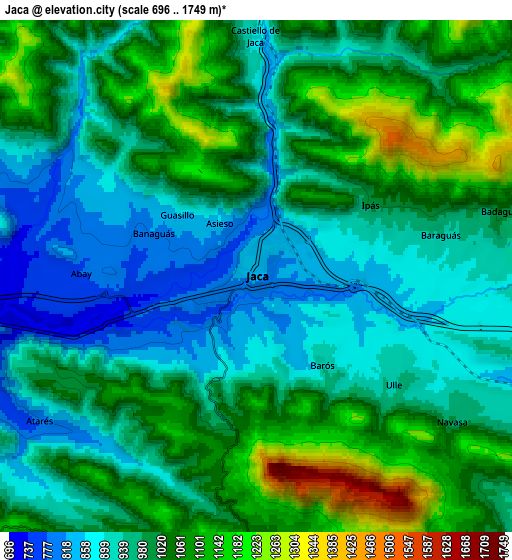
| Scale [m] | 730..1408 m | 696..1749 m | × |
| Scale [ft] | 2395..4619 ft | 2283..5738 ft | × |
| Average | 891.8 m = 2926 ft | 994.2 m = 3262 ft | × |
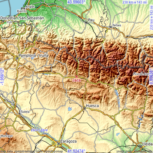
| Width | 7.2 km = 4.5 mi | 14.39 km = 8.9 mi | 230.3 km = 143.1 mi |
| Height | 7.2 km = 4.5 mi | 14.39 km = 8.9 mi | 230.3 km = 143.1 mi |
| ↑Max Latitude | 42.601336° | 42.633675° | 43.59603° |
| Latitude at center | 42.56898° | 42.56898° | 42.56898° |
| ↓Min Latitude | 42.536607° | 42.504218° | 41.52474° |
| ← Min Longitude | -0.593815° | -0.637761° | -1.95612° |
| Longitude center | -0.54987° | -0.54987° | -0.54987° |
| →Max Longitude | -0.505925° | -0.461979° | 0.85638° |
Nearby cities:
Cities around Jaca sort by population:
• Sabiñánigo elevation 807 m
16 km,  110°
110°
• Canfranc 1056 m
16.5 km,  6°
6°
• Villanúa 959 m
12.4 km,  4°
4°
• Puente la Reina de Jaca 593 m
19.5 km,  266°
266°
• Bailo 722 m
22.4 km,  252°
252°
• Castiello de Jaca 899 m
6.7 km,  359°
359°
• Yebra de Basa 886 m
23.8 km, 112°
• Santa Cruz de la Serós 801 m
11.5 km,  243°
243°
• Aragüés del Puerto 948 m
18.2 km,  327°
327°
• Jasa 945 m
16.9 km, 325°
• Borau 991 m
10.5 km,  342°
342°
• Biescas 860 m
19.9 km,  70°
70°
Multilingual:
 En español:
Jaca elevación 827 m.
 En France:
Jaca élévation 827 m.


Sources and notes:
- [note 1] Map square and city borders are not equal. Map elevation data is calculated only from area inside that square.
- [src 1] Elevation data from geonames database provided with same terms of usage.
- [src 2] The elevation map of Jaca is generated using elevation data from NASA's 3 arcsec (90m) resolution SRTM data.
- [src 3] Base (background) map © OpenStreetMap contributors tiles are generated by Geofabrik and OpenTopoMap.
Copyright & License:
This Jaca Elevation Map is licensed under CC BY-SA. You may reuse any part from this page, if you give a proper credit by linking to this URL:
 More info on terms of use page.