Fago elevation
Fago (Aragon, Provincia de Huesca), Spain elevation is 1178 meters and Fago elevation in feet is 3865 ft above sea level [src 1]. Fago is a seat of a third-order administrative division (feature code) with elevation that is 575 meters (1886 ft) bigger than average city elevation in Spain.
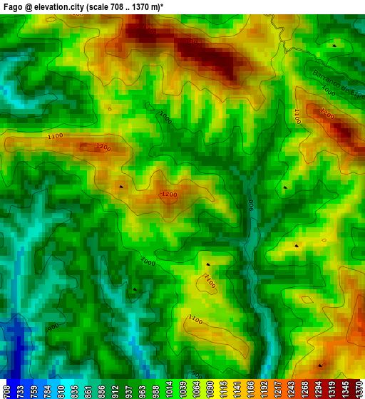
Below is the Elevation map of Fago, which displays elevation range with different colors. Scale of the first map is from 708 to 1370 m (2323 to 4495 ft) with average elevation of 1017.6 meters (=3339 ft) [note 1]
These maps also provides idea of topography and contour of this city, they are displayed at different zoom levels. More info about maps, scale and edge coordinates you can find below images.
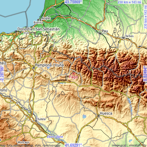
| \ | Map #1 | Topo.Map |
| Scale [m] | 708..1370 m | × |
| Scale [ft] | 2323..4495 ft | × |
| Average | 1017.6 m = 3339 ft | × |
| Width | 7.18 km = 4.5 mi | 229.7 km = 142.7 mi |
| Height | 7.18 km = 4.5 mi | 229.7 km = 142.7 mi |
| ↑Max Latitude | 42.76667° | 43.75869° |
| Latitude at center | 42.7344° | 42.7344° |
| ↓Min Latitude | 42.702113° | 41.69291° |
| ← Min Longitude | -0.925255° | -2.28756° |
| Longitude center | -0.88131° | -0.88131° |
| →Max Longitude | -0.837365° | 0.52494° |
Nearby cities:
Cities around Fago sort by population:
• Echo elevation 821 m
10.7 km,  87°
87°
• Ansó 859 m
5 km,  58°
58°
• Salvatierra de Esca 591 m
12.4 km,  234°
234°
• Navascués 616 m
19.4 km,  264°
264°
• Garde 734 m
7.1 km,  329°
329°
• Sigüés 522 m
15.8 km,  222°
222°
• Aragüés del Puerto 948 m
17.5 km,  100°
100°
• Jasa 945 m
18.1 km, 104°
• Urzainqui 766 m
11.9 km, 333°
• Mianos 624 m
17.6 km,  199°
199°
• Castillonuevo 802 m
13.5 km,  244°
244°
• Artieda 635 m
18.6 km,  206°
206°
Multilingual:
 En español:
Fago elevación 1178 m.
 En France:
Fago élévation 1178 m.


Sources and notes:
- [note 1] Map square and city borders are not equal. Map elevation data is calculated only from area inside that square.
- [src 1] Elevation data from geonames database provided with same terms of usage.
- [src 2] The elevation map of Fago is generated using elevation data from NASA's 3 arcsec (90m) resolution SRTM data.
- [src 3] Base (background) map © OpenStreetMap contributors tiles are generated by Geofabrik and OpenTopoMap.
Copyright & License:
This Fago Elevation Map is licensed under CC BY-SA. You may reuse any part from this page, if you give a proper credit by linking to this URL:
 More info on terms of use page.