Castillonuevo elevation
Castillonuevo (Navarre, Provincia de Navarra), Spain elevation is 802 meters and Castillonuevo elevation in feet is 2631 ft above sea level [src 1]. Castillonuevo is a seat of a third-order administrative division (feature code) with elevation that is 199 meters (653 ft) bigger than average city elevation in Spain.
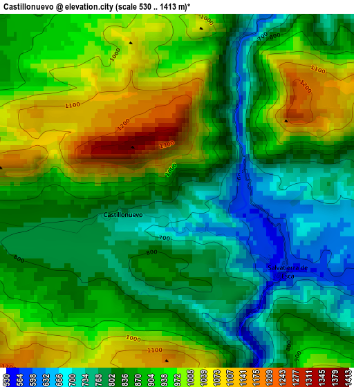
Below is the Elevation map of Castillonuevo, which displays elevation range with different colors. Scale of the first map is from 530 to 1413 m (1739 to 4636 ft) with average elevation of 889 meters (=2917 ft) [note 1]
These maps also provides idea of topography and contour of this city, they are displayed at different zoom levels. More info about maps, scale and edge coordinates you can find below images.
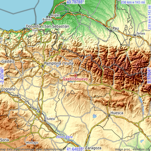
| \ | Map #1 | Topo.Map |
| Scale [m] | 530..1413 m | × |
| Scale [ft] | 1739..4636 ft | × |
| Average | 889 m = 2917 ft | × |
| Width | 7.18 km = 4.5 mi | 229.9 km = 142.9 mi |
| Height | 7.18 km = 4.5 mi | 229.9 km = 142.9 mi |
| ↑Max Latitude | 42.714997° | 43.70785° |
| Latitude at center | 42.6827° | 42.6827° |
| ↓Min Latitude | 42.650387° | 41.64035° |
| ← Min Longitude | -1.075155° | -2.43746° |
| Longitude center | -1.03121° | -1.03121° |
| →Max Longitude | -0.987265° | 0.37504° |
Nearby cities:
Cities around Castillonuevo sort by population:
• Salvatierra de Esca elevation 591 m
2.6 km,  123°
123°
• Yesa 497 m
15.7 km,  243°
243°
• Navascués 616 m
8 km,  298°
298°
• Garde 734 m
14.7 km,  35°
35°
• Sigüés 522 m
6 km,  165°
165°
• Urzainqui 766 m
17.8 km,  22°
22°
• Javier 453 m
17.7 km,  234°
234°
• Undués de Lerda 628 m
17.2 km,  221°
221°
• Mianos 624 m
12.5 km,  149°
149°
• Bagüés 825 m
16.4 km, 154°
• Fago 1178 m
13.5 km,  64°
64°
• Artieda 635 m
11.5 km,  160°
160°
Multilingual:
 En español:
Castillonuevo elevación 802 m.
 En France:
Castillonuevo élévation 802 m.
 Auf Deutsch:
Castillonuevo höhe über dem Meeresspiegel ist 802 m.

Sources and notes:
- [note 1] Map square and city borders are not equal. Map elevation data is calculated only from area inside that square.
- [src 1] Elevation data from geonames database provided with same terms of usage.
- [src 2] The elevation map of Castillonuevo is generated using elevation data from NASA's 3 arcsec (90m) resolution SRTM data.
- [src 3] Base (background) map © OpenStreetMap contributors tiles are generated by Geofabrik and OpenTopoMap.
Copyright & License:
This Castillonuevo Elevation Map is licensed under CC BY-SA. You may reuse any part from this page, if you give a proper credit by linking to this URL:
 More info on terms of use page.