Bagüés elevation
Bagüés (Aragon, Provincia de Zaragoza), Spain elevation is 825 meters and Bagüés elevation in feet is 2707 ft above sea level [src 1]. Bagüés is a seat of a third-order administrative division (feature code) with elevation that is 222 meters (728 ft) bigger than average city elevation in Spain.
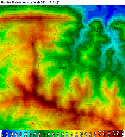
Below is the Elevation map of Bagüés, which displays elevation range with different colors. Scale of the first map is from 581 to 1118 m (1906 to 3668 ft) with average elevation of 876.8 meters (=2877 ft) [note 1]
These maps also provides idea of topography and contour of this city, they are displayed at different zoom levels. More info about maps, scale and edge coordinates you can find below images.
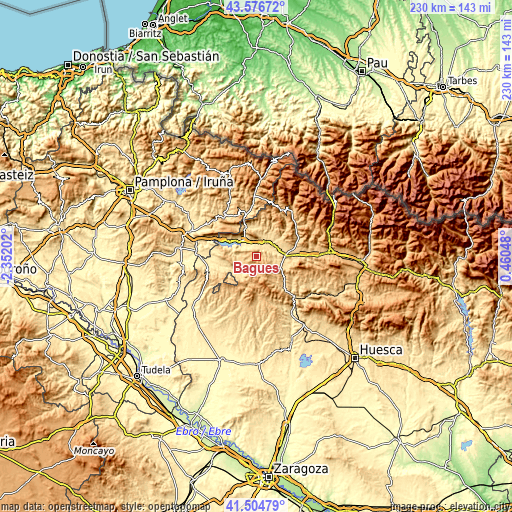
| \ | Map #1 | Topo.Map |
| Scale [m] | 581..1118 m | × |
| Scale [ft] | 1906..3668 ft | × |
| Average | 876.8 m = 2877 ft | × |
| Width | 7.2 km = 4.5 mi | 230.4 km = 143.2 mi |
| Height | 7.2 km = 4.5 mi | 230.4 km = 143.2 mi |
| ↑Max Latitude | 42.581716° | 43.57672° |
| Latitude at center | 42.54935° | 42.54935° |
| ↓Min Latitude | 42.516967° | 41.50479° |
| ← Min Longitude | -0.989715° | -2.35202° |
| Longitude center | -0.94577° | -0.94577° |
| →Max Longitude | -0.901825° | 0.46048° |
Nearby cities:
Cities around Bagüés sort by population:
• Salvatierra de Esca elevation 591 m
14.3 km,  340°
340°
• Puente la Reina de Jaca 593 m
13 km,  85°
85°
• Bailo 722 m
11.9 km,  112°
112°
• Sigüés 522 m
10.5 km,  328°
328°
• Lobera de Onsella 668 m
10.1 km,  218°
218°
• Longás 750 m
7.7 km,  172°
172°
• Urriés 548 m
15.5 km,  257°
257°
• Navardún 484 m
17.1 km, 256°
• Isuerre 612 m
11.2 km,  232°
232°
• Mianos 624 m
4.1 km,  349°
349°
• Castillonuevo 802 m
16.4 km, 334°
• Artieda 635 m
5.1 km,  321°
321°
Multilingual:
 En español:
Bagüés elevación 825 m.
 En France:
Bagüés élévation 825 m.


Sources and notes:
- [note 1] Map square and city borders are not equal. Map elevation data is calculated only from area inside that square.
- [src 1] Elevation data from geonames database provided with same terms of usage.
- [src 2] The elevation map of Bagüés is generated using elevation data from NASA's 3 arcsec (90m) resolution SRTM data.
- [src 3] Base (background) map © OpenStreetMap contributors tiles are generated by Geofabrik and OpenTopoMap.
Copyright & License:
This Bagüés Elevation Map is licensed under CC BY-SA. You may reuse any part from this page, if you give a proper credit by linking to this URL:
 More info on terms of use page.