Castro elevation
Castro (Galicia, Provincia de Lugo), Spain elevation is 667 meters and Castro elevation in feet is 2188 ft above sea level [src 1]. Castro is a populated place (feature code) with elevation that is 64 meters (210 ft) bigger than average city elevation in Spain.
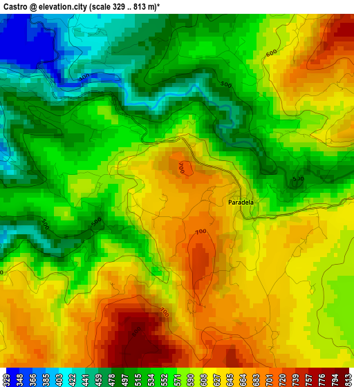
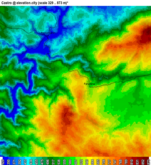
Below is the Elevation map of Castro, which displays elevation range with different colors. Scale of the first map is from 329 to 813 m (1079 to 2667 ft) with average elevation of 581.9 meters (=1909 ft) [note 1]
These maps also provides idea of topography and contour of this city, they are displayed at different zoom levels. More info about maps, scale and edge coordinates you can find below images.
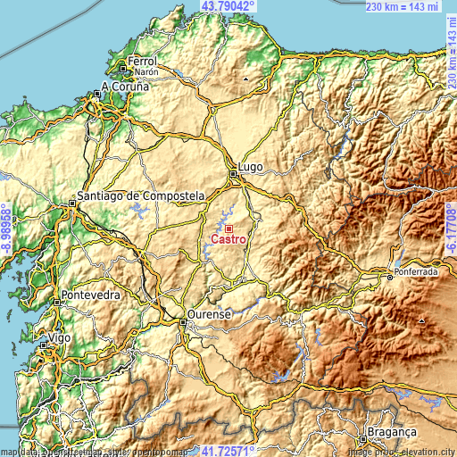
| \ | Map #1 | Map #2 | Topo.Map |
| Scale [m] | 329..813 m | 329..873 m | × |
| Scale [ft] | 1079..2667 ft | 1079..2864 ft | × |
| Average | 581.9 m = 1909 ft | 562.1 m = 1844 ft | × |
| Width | 7.17 km = 4.5 mi | 14.35 km = 8.9 mi | 229.6 km = 142.7 mi |
| Height | 7.17 km = 4.5 mi | 14.35 km = 8.9 mi | 229.6 km = 142.7 mi |
| ↑Max Latitude | 42.798923° | 42.831159° | 43.79042° |
| Latitude at center | 42.76667° | 42.76667° | 42.76667° |
| ↓Min Latitude | 42.7344° | 42.702114° | 41.72571° |
| ← Min Longitude | -7.627275° | -7.671221° | -8.98958° |
| Longitude center | -7.58333° | -7.58333° | -7.58333° |
| →Max Longitude | -7.539385° | -7.495439° | -6.17708° |
Nearby cities:
Cities around Castro sort by population:
• Sarria elevation 422 m
13.9 km,  83°
83°
• Chantada 491 m
23.3 km,  221°
221°
• Corgo 441 m
23.3 km,  32°
32°
• Monterroso 549 m
20.7 km,  277°
277°
• Taboada 623 m
21 km,  248°
248°
• Láncara 452 m
22.9 km,  61°
61°
• Paradela 606 m
1.4 km,  90°
90°
• Samos 532 m
21.4 km,  100°
100°
• Ourol 465 m
11.8 km,  347°
347°
• Bóveda 366 m
18 km,  151°
151°
• Guntín 445 m
16.1 km,  326°
326°
• Portomarín 367 m
5.2 km, 328°
Multilingual:
 En español:
Castro elevación 667 m.
 En France:
Castro élévation 667 m.


Sources and notes:
- [note 1] Map square and city borders are not equal. Map elevation data is calculated only from area inside that square.
- [src 1] Elevation data from geonames database provided with same terms of usage.
- [src 2] The elevation map of Castro is generated using elevation data from NASA's 3 arcsec (90m) resolution SRTM data.
- [src 3] Base (background) map © OpenStreetMap contributors tiles are generated by Geofabrik and OpenTopoMap.
Copyright & License:
This Castro Elevation Map is licensed under CC BY-SA. You may reuse any part from this page, if you give a proper credit by linking to this URL:
 More info on terms of use page.