Portomarín elevation
Portomarín (Galicia, Provincia de Lugo), Spain elevation is 367 meters and Portomarín elevation in feet is 1204 ft above sea level [src 1]. Portomarín is a seat of a third-order administrative division (feature code) with elevation that is 236 meters (774 ft) smaller than average city elevation in Spain.
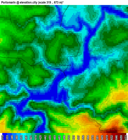
Below is the Elevation map of Portomarín, which displays elevation range with different colors. Scale of the first map is from 319 to 673 m (1047 to 2208 ft) with average elevation of 426.5 meters (=1399 ft) [note 1]
These maps also provides idea of topography and contour of this city, they are displayed at different zoom levels. More info about maps, scale and edge coordinates you can find below images.
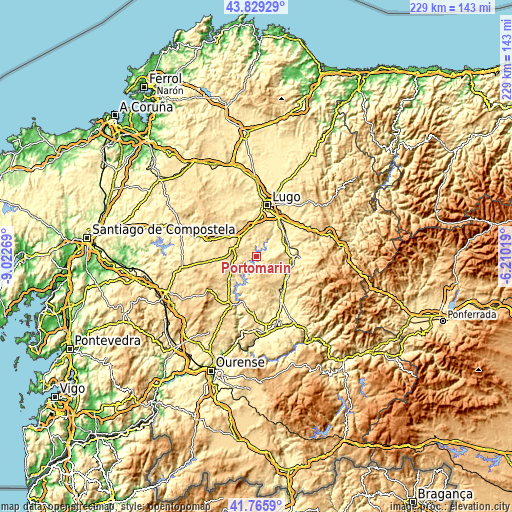
| \ | Map #1 | Topo.Map |
| Scale [m] | 319..673 m | × |
| Scale [ft] | 1047..2208 ft | × |
| Average | 426.5 m = 1399 ft | × |
| Width | 7.17 km = 4.5 mi | 229.4 km = 142.5 mi |
| Height | 7.17 km = 4.5 mi | 229.4 km = 142.5 mi |
| ↑Max Latitude | 42.838432° | 43.82929° |
| Latitude at center | 42.8062° | 42.8062° |
| ↓Min Latitude | 42.773951° | 41.7659° |
| ← Min Longitude | -7.660385° | -9.02269° |
| Longitude center | -7.61644° | -7.61644° |
| →Max Longitude | -7.572495° | -6.21019° |
Nearby cities:
Cities around Portomarín sort by population:
• Lugo elevation 465 m
23.2 km,  12°
12°
• Sarria 422 m
16.7 km,  99°
99°
• Castro 667 m
5.2 km,  148°
148°
• Corgo 441 m
21.5 km,  44°
44°
• Monterroso 549 m
17.8 km,  265°
265°
• Taboada 623 m
20.7 km,  234°
234°
• Láncara 452 m
23.7 km,  74°
74°
• Paradela 606 m
6 km,  137°
137°
• Samos 532 m
25.2 km,  109°
109°
• Ourol 465 m
7.1 km,  1°
1°
• Bóveda 366 m
23.2 km, 150°
• Guntín 445 m
10.9 km,  325°
325°
Multilingual:
 En español:
Puertomarín elevación 367 m.
 En France:
Portomarín élévation 367 m.
 Auf Deutsch:
Portomarín höhe über dem Meeresspiegel ist 367 m.

Sources and notes:
- [note 1] Map square and city borders are not equal. Map elevation data is calculated only from area inside that square.
- [src 1] Elevation data from geonames database provided with same terms of usage.
- [src 2] The elevation map of Portomarín is generated using elevation data from NASA's 3 arcsec (90m) resolution SRTM data.
- [src 3] Base (background) map © OpenStreetMap contributors tiles are generated by Geofabrik and OpenTopoMap.
Copyright & License:
This Portomarín Elevation Map is licensed under CC BY-SA. You may reuse any part from this page, if you give a proper credit by linking to this URL:
 More info on terms of use page.