Cobeta elevation
Cobeta (Castille-La Mancha, Provincia de Guadalajara), Spain elevation is 1123 meters and Cobeta elevation in feet is 3684 ft above sea level [src 1]. Cobeta is a seat of a third-order administrative division (feature code) with elevation that is 520 meters (1706 ft) bigger than average city elevation in Spain.
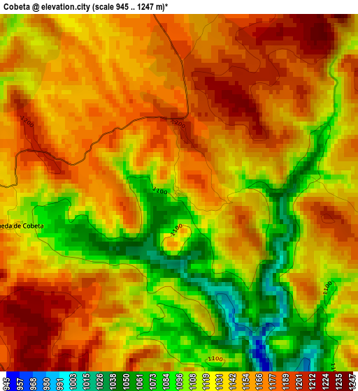
Below is the Elevation map of Cobeta, which displays elevation range with different colors. Scale of the first map is from 945 to 1247 m (3100 to 4091 ft) with average elevation of 1142 meters (=3747 ft) [note 1]
These maps also provides idea of topography and contour of this city, they are displayed at different zoom levels. More info about maps, scale and edge coordinates you can find below images.
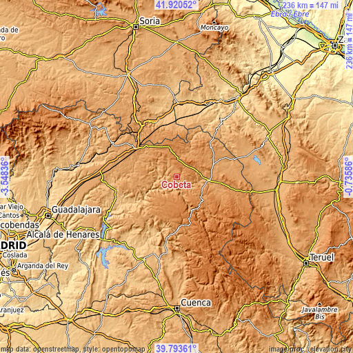
| \ | Map #1 | Topo.Map |
| Scale [m] | 945..1247 m | × |
| Scale [ft] | 3100..4091 ft | × |
| Average | 1142 m = 3747 ft | × |
| Width | 7.39 km = 4.6 mi | 236.5 km = 147 mi |
| Height | 7.39 km = 4.6 mi | 236.5 km = 147 mi |
| ↑Max Latitude | 40.898825° | 41.92052° |
| Latitude at center | 40.8656° | 40.8656° |
| ↓Min Latitude | 40.832358° | 39.79361° |
| ← Min Longitude | -2.186055° | -3.54836° |
| Longitude center | -2.14211° | -2.14211° |
| →Max Longitude | -2.098165° | -0.73586° |
Nearby cities:
Cities around Cobeta sort by population:
• Corduente elevation 1063 m
14 km,  100°
100°
• Zaorejas 1229 m
12.5 km,  203°
203°
• Riba de Saelices 984 m
14 km,  291°
291°
• Ablanque 1033 m
7.9 km,  297°
297°
• Olmeda de Cobeta 1135 m
3.5 km,  259°
259°
• Anquela del Ducado 1188 m
11.7 km,  4°
4°
• Saelices de la Sal 1001 m
15.9 km, 286°
• Mazarete 1207 m
15.1 km,  354°
354°
• Huertahernando 1151 m
13.1 km,  248°
248°
• Selas 1220 m
10.1 km,  19°
19°
• Torremocha del Pinar 1289 m
8.6 km,  71°
71°
• Herrería 1089 m
15.5 km,  80°
80°
Multilingual:
 En español:
Cobeta elevación 1123 m.
 En France:
Cobeta élévation 1123 m.


Sources and notes:
- [note 1] Map square and city borders are not equal. Map elevation data is calculated only from area inside that square.
- [src 1] Elevation data from geonames database provided with same terms of usage.
- [src 2] The elevation map of Cobeta is generated using elevation data from NASA's 3 arcsec (90m) resolution SRTM data.
- [src 3] Base (background) map © OpenStreetMap contributors tiles are generated by Geofabrik and OpenTopoMap.
Copyright & License:
This Cobeta Elevation Map is licensed under CC BY-SA. You may reuse any part from this page, if you give a proper credit by linking to this URL:
 More info on terms of use page.