Selas elevation
Selas (Castille-La Mancha, Provincia de Guadalajara), Spain elevation is 1220 meters and Selas elevation in feet is 4003 ft above sea level [src 1]. Selas is a seat of a third-order administrative division (feature code) with elevation that is 617 meters (2024 ft) bigger than average city elevation in Spain.
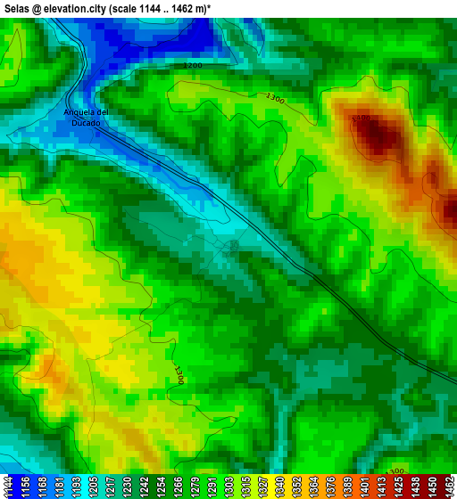
Below is the Elevation map of Selas, which displays elevation range with different colors. Scale of the first map is from 1144 to 1462 m (3753 to 4797 ft) with average elevation of 1275.1 meters (=4183 ft) [note 1]
These maps also provides idea of topography and contour of this city, they are displayed at different zoom levels. More info about maps, scale and edge coordinates you can find below images.
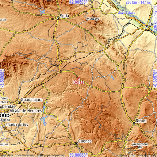
| \ | Map #1 | Topo.Map |
| Scale [m] | 1144..1462 m | × |
| Scale [ft] | 3753..4797 ft | × |
| Average | 1275.1 m = 4183 ft | × |
| Width | 7.38 km = 4.6 mi | 236.2 km = 146.8 mi |
| Height | 7.38 km = 4.6 mi | 236.2 km = 146.8 mi |
| ↑Max Latitude | 40.984682° | 42.00503° |
| Latitude at center | 40.9515° | 40.9515° |
| ↓Min Latitude | 40.918301° | 39.88088° |
| ← Min Longitude | -2.145975° | -3.50828° |
| Longitude center | -2.10203° | -2.10203° |
| →Max Longitude | -2.058085° | -0.69578° |
Nearby cities:
Cities around Selas sort by population:
• Corduente elevation 1063 m
15.9 km,  139°
139°
• Maranchón 1251 m
13.7 km,  321°
321°
• Tartanedo 1191 m
15.6 km,  72°
72°
• Ablanque 1033 m
11.9 km,  240°
240°
• Olmeda de Cobeta 1135 m
12.3 km,  213°
213°
• Cobeta 1123 m
10.1 km,  199°
199°
• Anquela del Ducado 1188 m
3.2 km,  311°
311°
• Mazarete 1207 m
7.3 km, 318°
• Torremocha del Pinar 1289 m
8.4 km,  145°
145°
• Establés 1148 m
9 km,  46°
46°
• Herrería 1089 m
13.8 km,  120°
120°
• Pardos 1185 m
14.8 km,  91°
91°
Multilingual:
 En español:
Selas elevación 1220 m.
 En France:
Selas élévation 1220 m.


Sources and notes:
- [note 1] Map square and city borders are not equal. Map elevation data is calculated only from area inside that square.
- [src 1] Elevation data from geonames database provided with same terms of usage.
- [src 2] The elevation map of Selas is generated using elevation data from NASA's 3 arcsec (90m) resolution SRTM data.
- [src 3] Base (background) map © OpenStreetMap contributors tiles are generated by Geofabrik and OpenTopoMap.
Copyright & License:
This Selas Elevation Map is licensed under CC BY-SA. You may reuse any part from this page, if you give a proper credit by linking to this URL:
 More info on terms of use page.