Pardos elevation
Pardos (Castille-La Mancha, Provincia de Guadalajara), Spain elevation is 1185 meters and Pardos elevation in feet is 3888 ft above sea level [src 1]. Pardos is a seat of a third-order administrative division (feature code) with elevation that is 582 meters (1909 ft) bigger than average city elevation in Spain.
Below is the Elevation map of Pardos, which displays elevation range with different colors. Scale of the first map is from 1134 to 1402 m (3720 to 4600 ft) with average elevation of 1229.9 meters (=4035 ft) [note 1]
These maps also provides idea of topography and contour of this city, they are displayed at different zoom levels. More info about maps, scale and edge coordinates you can find below images.
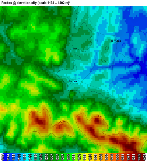
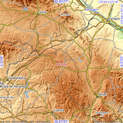
| \ | Map #1 | Topo.Map |
| Scale [m] | 1134..1402 m | × |
| Scale [ft] | 3720..4600 ft | × |
| Average | 1229.9 m = 4035 ft | × |
| Width | 7.38 km = 4.6 mi | 236.2 km = 146.8 mi |
| Height | 7.38 km = 4.6 mi | 236.2 km = 146.8 mi |
| ↑Max Latitude | 40.981364° | 42.00177° |
| Latitude at center | 40.94818° | 40.94818° |
| ↓Min Latitude | 40.91498° | 39.87751° |
| ← Min Longitude | -1.969495° | -3.3318° |
| Longitude center | -1.92555° | -1.92555° |
| →Max Longitude | -1.881605° | -0.5193° |
Nearby cities:
Cities around Pardos sort by population:
• Molina de Aragón elevation 1067 m
12.1 km,  164°
164°
• Corduente 1063 m
12.5 km,  200°
200°
• Tortuera 1114 m
11.1 km,  76°
76°
• Tartanedo 1191 m
5 km,  0°
0°
• Milmarcos 1062 m
15.9 km,  15°
15°
• Rillo de Gallo 1057 m
9.2 km,  186°
186°
• Selas 1220 m
14.8 km,  271°
271°
• Torremocha del Pinar 1289 m
12 km,  236°
236°
• Rueda de la Sierra 1150 m
6.9 km,  119°
119°
• Establés 1148 m
10.6 km,  308°
308°
• Torrubia 1173 m
2.9 km,  46°
46°
• Herrería 1089 m
7.3 km, 203°
Multilingual:
 En español:
Pardos elevación 1185 m.
 En France:
Pardos élévation 1185 m.


Sources and notes:
- [note 1] Map square and city borders are not equal. Map elevation data is calculated only from area inside that square.
- [src 1] Elevation data from geonames database provided with same terms of usage.
- [src 2] The elevation map of Pardos is generated using elevation data from NASA's 3 arcsec (90m) resolution SRTM data.
- [src 3] Base (background) map © OpenStreetMap contributors tiles are generated by Geofabrik and OpenTopoMap.
Copyright & License:
This Pardos Elevation Map is licensed under CC BY-SA. You may reuse any part from this page, if you give a proper credit by linking to this URL:
 More info on terms of use page.