Tortuera elevation
Tortuera (Castille-La Mancha, Provincia de Guadalajara), Spain elevation is 1114 meters and Tortuera elevation in feet is 3655 ft above sea level [src 1]. Tortuera is a seat of a third-order administrative division (feature code) with elevation that is 511 meters (1677 ft) bigger than average city elevation in Spain.
Below is the Elevation map of Tortuera, which displays elevation range with different colors. Scale of the first map is from 1060 to 1186 m (3478 to 3891 ft) with average elevation of 1123.8 meters (=3687 ft) [note 1]
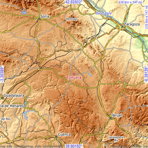
These maps also provides idea of topography and contour of this city, they are displayed at different zoom levels. More info about maps, scale and edge coordinates you can find below images.
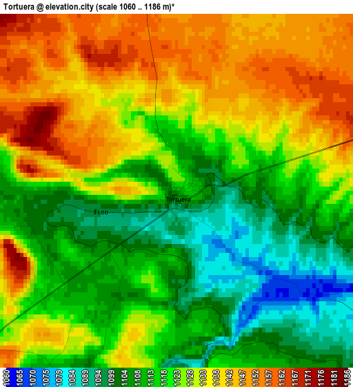
| \ | Map #1 | Topo.Map |
| Scale [m] | 1060..1186 m | × |
| Scale [ft] | 3478..3891 ft | × |
| Average | 1123.8 m = 3687 ft | × |
| Width | 7.38 km = 4.6 mi | 236.1 km = 146.7 mi |
| Height | 7.38 km = 4.6 mi | 236.1 km = 146.7 mi |
| ↑Max Latitude | 41.004982° | 42.02502° |
| Latitude at center | 40.97181° | 40.97181° |
| ↓Min Latitude | 40.938622° | 39.90152° |
| ← Min Longitude | -1.841585° | -3.20389° |
| Longitude center | -1.79764° | -1.79764° |
| →Max Longitude | -1.753695° | -0.39139° |
Nearby cities:
Cities around Tortuera sort by population:
• Molina de Aragón elevation 1067 m
16.1 km,  207°
207°
• Tartanedo 1191 m
10.9 km,  282°
282°
• Cimballa 919 m
14.5 km,  8°
8°
• Milmarcos 1062 m
14.3 km,  332°
332°
• Fuentelsaz 1123 m
11.7 km,  346°
346°
• Campillo de Dueñas 1118 m
13.6 km,  135°
135°
• Torralba de los Frailes 1093 m
13.6 km,  58°
58°
• Embid 1084 m
7.2 km,  89°
89°
• Rueda de la Sierra 1150 m
7.7 km,  218°
218°
• Torrubia 1173 m
8.7 km,  265°
265°
• Aldehuela de Liestos 997 m
13.1 km,  38°
38°
• Pardos 1185 m
11.1 km,  256°
256°
Multilingual:
 En español:
Tortuera elevación 1114 m.
 En France:
Tortuera élévation 1114 m.
 Auf Deutsch:
Tortuera höhe über dem Meeresspiegel ist 1114 m.

Sources and notes:
- [note 1] Map square and city borders are not equal. Map elevation data is calculated only from area inside that square.
- [src 1] Elevation data from geonames database provided with same terms of usage.
- [src 2] The elevation map of Tortuera is generated using elevation data from NASA's 3 arcsec (90m) resolution SRTM data.
- [src 3] Base (background) map © OpenStreetMap contributors tiles are generated by Geofabrik and OpenTopoMap.
Copyright & License:
This Tortuera Elevation Map is licensed under CC BY-SA. You may reuse any part from this page, if you give a proper credit by linking to this URL:
 More info on terms of use page.