Molina de Aragón elevation
Molina de Aragón (Castille-La Mancha, Provincia de Guadalajara), Spain elevation is 1067 meters and Molina de Aragón elevation in feet is 3501 ft above sea level [src 1]. Molina de Aragón is a seat of a third-order administrative division (feature code) with elevation that is 464 meters (1522 ft) bigger than average city elevation in Spain.
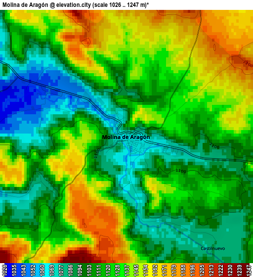
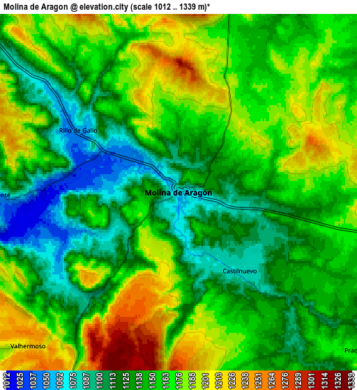
Below is the Elevation map of Molina de Aragón, which displays elevation range with different colors. Scale of the first map is from 1026 to 1247 m (3366 to 4091 ft) with average elevation of 1121.1 meters (=3678 ft) [note 1]
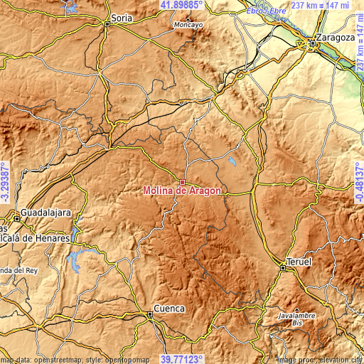
These maps also provides idea of topography and contour of this city, they are displayed at different zoom levels. More info about maps, scale and edge coordinates you can find below images.
| \ | Map #1 | Map #2 | Topo.Map |
| Scale [m] | 1026..1247 m | 1012..1339 m | × |
| Scale [ft] | 3366..4091 ft | 3320..4393 ft | × |
| Average | 1121.1 m = 3678 ft | 1152.8 m = 3782 ft | × |
| Width | 7.39 km = 4.6 mi | 14.79 km = 9.2 mi | 236.6 km = 147 mi |
| Height | 7.39 km = 4.6 mi | 14.79 km = 9.2 mi | 236.6 km = 147 mi |
| ↑Max Latitude | 40.876816° | 40.910036° | 41.89885° |
| Latitude at center | 40.84358° | 40.84358° | 40.84358° |
| ↓Min Latitude | 40.810327° | 40.777058° | 39.77123° |
| ← Min Longitude | -1.931565° | -1.975511° | -3.29387° |
| Longitude center | -1.88762° | -1.88762° | -1.88762° |
| →Max Longitude | -1.843675° | -1.799729° | -0.48137° |
Nearby cities:
Cities around Molina de Aragón sort by population:
• Corduente elevation 1063 m
7.6 km,  269°
269°
• Prados Redondos 1158 m
10.3 km,  129°
129°
• Rillo de Gallo 1057 m
4.9 km,  301°
301°
• Rueda de la Sierra 1150 m
8.7 km,  18°
18°
• Tierzo 1145 m
11.1 km,  199°
199°
• Valhermoso 1229 m
8.9 km,  223°
223°
• Castellar de la Muela 1213 m
11.1 km,  104°
104°
• Herrería 1089 m
7.9 km,  309°
309°
• Torrecuadrada de Molina 1189 m
12.5 km,  147°
147°
• Torremochuela 1169 m
9.5 km,  156°
156°
• Castilnuevo 1085 m
4.1 km,  142°
142°
• Pardos 1185 m
12.1 km,  344°
344°
Multilingual:
 En español:
Molina de Aragón elevación 1067 m.
 En France:
Molina d'Aragon élévation 1067 m.
 Auf Deutsch:
Molina de Aragón höhe über dem Meeresspiegel ist 1067 m.

Sources and notes:
- [note 1] Map square and city borders are not equal. Map elevation data is calculated only from area inside that square.
- [src 1] Elevation data from geonames database provided with same terms of usage.
- [src 2] The elevation map of Molina de Aragón is generated using elevation data from NASA's 3 arcsec (90m) resolution SRTM data.
- [src 3] Base (background) map © OpenStreetMap contributors tiles are generated by Geofabrik and OpenTopoMap.
Copyright & License:
This Molina de Aragón Elevation Map is licensed under CC BY-SA. You may reuse any part from this page, if you give a proper credit by linking to this URL:
 More info on terms of use page.