Tierzo elevation
Tierzo (Castille-La Mancha, Provincia de Guadalajara), Spain elevation is 1145 meters and Tierzo elevation in feet is 3757 ft above sea level [src 1]. Tierzo is a seat of a third-order administrative division (feature code) with elevation that is 542 meters (1778 ft) bigger than average city elevation in Spain.
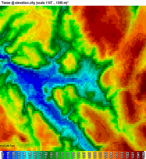
Below is the Elevation map of Tierzo, which displays elevation range with different colors. Scale of the first map is from 1107 to 1350 m (3632 to 4429 ft) with average elevation of 1237.2 meters (=4059 ft) [note 1]
These maps also provides idea of topography and contour of this city, they are displayed at different zoom levels. More info about maps, scale and edge coordinates you can find below images.
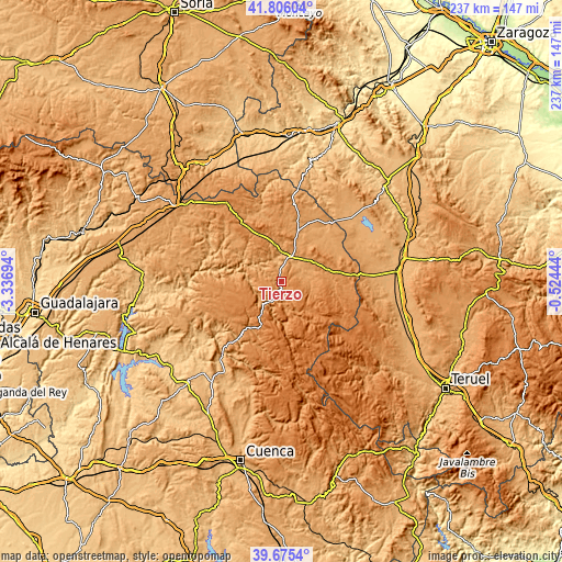
| \ | Map #1 | Topo.Map |
| Scale [m] | 1107..1350 m | × |
| Scale [ft] | 3632..4429 ft | × |
| Average | 1237.2 m = 4059 ft | × |
| Width | 7.4 km = 4.6 mi | 236.9 km = 147.2 mi |
| Height | 7.4 km = 4.6 mi | 236.9 km = 147.2 mi |
| ↑Max Latitude | 40.782533° | 41.80604° |
| Latitude at center | 40.74925° | 40.74925° |
| ↓Min Latitude | 40.71595° | 39.6754° |
| ← Min Longitude | -1.974635° | -3.33694° |
| Longitude center | -1.93069° | -1.93069° |
| →Max Longitude | -1.886745° | -0.52444° |
Nearby cities:
Cities around Tierzo sort by population:
• Molina de Aragón elevation 1067 m
11.1 km,  19°
19°
• Corduente 1063 m
11.2 km,  338°
338°
• Prados Redondos 1158 m
12.2 km,  71°
71°
• Taravilla 1320 m
6.6 km,  208°
208°
• Valhermoso 1229 m
4.8 km,  327°
327°
• Baños de Tajo 1287 m
4.7 km,  219°
219°
• Terzaga 1183 m
6.4 km,  159°
159°
• Pinilla de Molina 1220 m
8.8 km,  151°
151°
• Torrecuadrada de Molina 1189 m
10.4 km,  89°
89°
• Torremochuela 1169 m
7.7 km,  76°
76°
• Fuembellida 1222 m
5.8 km,  277°
277°
• Castilnuevo 1085 m
9.5 km,  40°
40°
Multilingual:
 En español:
Tierzo elevación 1145 m.
 En France:
Tierzo élévation 1145 m.


Sources and notes:
- [note 1] Map square and city borders are not equal. Map elevation data is calculated only from area inside that square.
- [src 1] Elevation data from geonames database provided with same terms of usage.
- [src 2] The elevation map of Tierzo is generated using elevation data from NASA's 3 arcsec (90m) resolution SRTM data.
- [src 3] Base (background) map © OpenStreetMap contributors tiles are generated by Geofabrik and OpenTopoMap.
Copyright & License:
This Tierzo Elevation Map is licensed under CC BY-SA. You may reuse any part from this page, if you give a proper credit by linking to this URL:
 More info on terms of use page.