Huertahernando elevation
Huertahernando (Castille-La Mancha, Provincia de Guadalajara), Spain elevation is 1151 meters and Huertahernando elevation in feet is 3776 ft above sea level [src 1]. Huertahernando is a seat of a third-order administrative division (feature code) with elevation that is 548 meters (1798 ft) bigger than average city elevation in Spain.
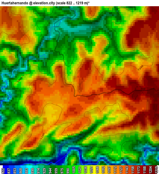
Below is the Elevation map of Huertahernando, which displays elevation range with different colors. Scale of the first map is from 822 to 1219 m (2697 to 3999 ft) with average elevation of 1046.9 meters (=3435 ft) [note 1]
These maps also provides idea of topography and contour of this city, they are displayed at different zoom levels. More info about maps, scale and edge coordinates you can find below images.
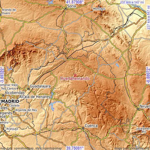
| \ | Map #1 | Topo.Map |
| Scale [m] | 822..1219 m | × |
| Scale [ft] | 2697..3999 ft | × |
| Average | 1046.9 m = 3435 ft | × |
| Width | 7.4 km = 4.6 mi | 236.6 km = 147 mi |
| Height | 7.4 km = 4.6 mi | 236.6 km = 147 mi |
| ↑Max Latitude | 40.856726° | 41.87908° |
| Latitude at center | 40.82348° | 40.82348° |
| ↓Min Latitude | 40.790217° | 39.75081° |
| ← Min Longitude | -2.330915° | -3.69322° |
| Longitude center | -2.28697° | -2.28697° |
| →Max Longitude | -2.243025° | -0.88072° |
Nearby cities:
Cities around Huertahernando sort by population:
• Zaorejas elevation 1229 m
9.9 km,  133°
133°
• Riba de Saelices 984 m
9.8 km,  354°
354°
• Sacecorbo 1120 m
11.1 km,  275°
275°
• Ablanque 1033 m
9.8 km,  32°
32°
• Olmeda de Cobeta 1135 m
9.6 km,  65°
65°
• Cobeta 1123 m
13.1 km, 68°
• Saelices de la Sal 1001 m
9.8 km,  341°
341°
• Sotodosos 1152 m
14 km,  320°
320°
• Armallones 1208 m
9.8 km,  187°
187°
• Esplegares 1154 m
8 km,  297°
297°
• Ocentejo 865 m
10.9 km,  238°
238°
• Valtablado del Río 842 m
15.6 km,  218°
218°
Multilingual:
 En español:
Huertahernando elevación 1151 m.
 En France:
Huertahernando élévation 1151 m.
 Auf Deutsch:
Huertahernando höhe über dem Meeresspiegel ist 1151 m.

Sources and notes:
- [note 1] Map square and city borders are not equal. Map elevation data is calculated only from area inside that square.
- [src 1] Elevation data from geonames database provided with same terms of usage.
- [src 2] The elevation map of Huertahernando is generated using elevation data from NASA's 3 arcsec (90m) resolution SRTM data.
- [src 3] Base (background) map © OpenStreetMap contributors tiles are generated by Geofabrik and OpenTopoMap.
Copyright & License:
This Huertahernando Elevation Map is licensed under CC BY-SA. You may reuse any part from this page, if you give a proper credit by linking to this URL:
 More info on terms of use page.