Hoz de Jaca elevation
Hoz de Jaca (Aragon, Provincia de Huesca), Spain elevation is 1267 meters and Hoz de Jaca elevation in feet is 4157 ft above sea level [src 1]. Hoz de Jaca is a seat of a third-order administrative division (feature code) with elevation that is 664 meters (2178 ft) bigger than average city elevation in Spain.
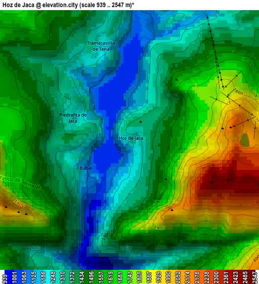
Below is the Elevation map of Hoz de Jaca, which displays elevation range with different colors. Scale of the first map is from 939 to 2547 m (3081 to 8356 ft) with average elevation of 1495.3 meters (=4906 ft) [note 1]
These maps also provides idea of topography and contour of this city, they are displayed at different zoom levels. More info about maps, scale and edge coordinates you can find below images.
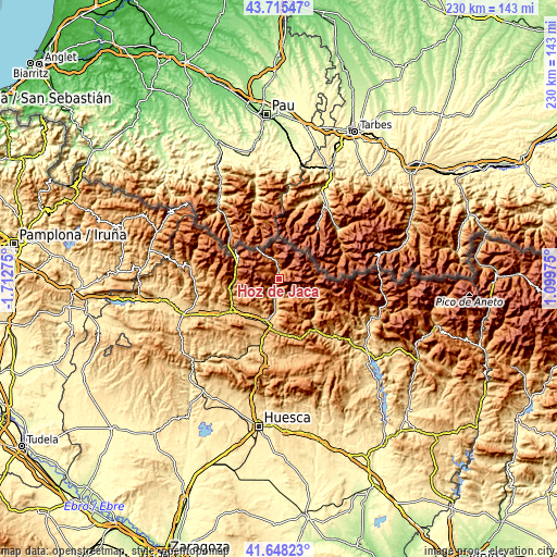
| \ | Map #1 | Topo.Map |
| Scale [m] | 939..2547 m | × |
| Scale [ft] | 3081..8356 ft | × |
| Average | 1495.3 m = 4906 ft | × |
| Width | 7.18 km = 4.5 mi | 229.9 km = 142.9 mi |
| Height | 7.18 km = 4.5 mi | 229.8 km = 142.8 mi |
| ↑Max Latitude | 42.722743° | 43.71547° |
| Latitude at center | 42.69045° | 42.69045° |
| ↓Min Latitude | 42.658141° | 41.64823° |
| ← Min Longitude | -0.350445° | -1.71275° |
| Longitude center | -0.3065° | -0.3065° |
| →Max Longitude | -0.262555° | 1.09975° |
Nearby cities:
Cities around Hoz de Jaca sort by population:
• Jaca elevation 827 m
24.1 km,  235°
235°
• Sabiñánigo 807 m
19.7 km,  194°
194°
• Sallent de Gállego 1289 m
9.3 km,  345°
345°
• Canfranc 1056 m
18.1 km,  279°
279°
• Broto 895 m
17.8 km,  122°
122°
• Villanúa 959 m
18.9 km,  266°
266°
• Fiscal 767 m
26.5 km,  144°
144°
• Castiello de Jaca 899 m
21 km,  251°
251°
• Yebra de Basa 886 m
22.8 km,  174°
174°
• Yésero 1130 m
9.2 km,  149°
149°
• Borau 991 m
23.3 km,  261°
261°
• Biescas 860 m
6.9 km, 190°
Multilingual:
 En español:
Hoz de Jaca elevación 1267 m.
 En France:
Hoz de Jaca élévation 1267 m.
 Auf Deutsch:
Hoz de Jaca höhe über dem Meeresspiegel ist 1267 m.

Sources and notes:
- [note 1] Map square and city borders are not equal. Map elevation data is calculated only from area inside that square.
- [src 1] Elevation data from geonames database provided with same terms of usage.
- [src 2] The elevation map of Hoz de Jaca is generated using elevation data from NASA's 3 arcsec (90m) resolution SRTM data.
- [src 3] Base (background) map © OpenStreetMap contributors tiles are generated by Geofabrik and OpenTopoMap.
Copyright & License:
This Hoz de Jaca Elevation Map is licensed under CC BY-SA. You may reuse any part from this page, if you give a proper credit by linking to this URL:
 More info on terms of use page.