Fiscal elevation
Fiscal (Aragon, Provincia de Huesca), Spain elevation is 767 meters and Fiscal elevation in feet is 2516 ft above sea level [src 1]. Fiscal is a seat of a third-order administrative division (feature code) with elevation that is 164 meters (538 ft) bigger than average city elevation in Spain.
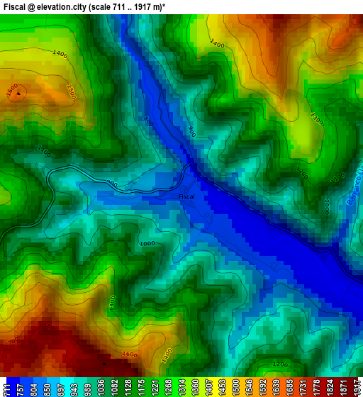
Below is the Elevation map of Fiscal, which displays elevation range with different colors. Scale of the first map is from 711 to 1917 m (2333 to 6289 ft) with average elevation of 1148.9 meters (=3769 ft) [note 1]
These maps also provides idea of topography and contour of this city, they are displayed at different zoom levels. More info about maps, scale and edge coordinates you can find below images.
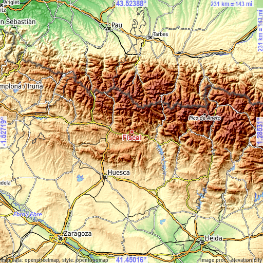
| \ | Map #1 | Topo.Map |
| Scale [m] | 711..1917 m | × |
| Scale [ft] | 2333..6289 ft | × |
| Average | 1148.9 m = 3769 ft | × |
| Width | 7.21 km = 4.5 mi | 230.6 km = 143.3 mi |
| Height | 7.21 km = 4.5 mi | 230.6 km = 143.3 mi |
| ↑Max Latitude | 42.528004° | 43.52388° |
| Latitude at center | 42.49561° | 42.49561° |
| ↓Min Latitude | 42.463199° | 41.45016° |
| ← Min Longitude | -0.164885° | -1.52719° |
| Longitude center | -0.12094° | -0.12094° |
| →Max Longitude | -0.076995° | 1.28531° |
Nearby cities:
Cities around Fiscal sort by population:
• Sabiñánigo elevation 807 m
20.3 km,  277°
277°
• Aínsa 576 m
23.2 km,  112°
112°
• Boltaña 654 m
16.5 km, 109°
• Broto 895 m
12.1 km,  359°
359°
• Bielsa 1034 m
31.7 km,  61°
61°
• Laspuña 714 m
22.6 km,  87°
87°
• Puértolas 1157 m
21.5 km,  74°
74°
• Yebra de Basa 886 m
13.2 km,  265°
265°
• Labuerda 565 m
21.6 km,  102°
102°
• Yésero 1130 m
17.3 km,  322°
322°
• Hoz de Jaca 1267 m
26.5 km, 324°
• Biescas 860 m
22.1 km,  312°
312°
Multilingual:
 En español:
Fiscal elevación 767 m.
 En France:
Fiscal élévation 767 m.


Sources and notes:
- [note 1] Map square and city borders are not equal. Map elevation data is calculated only from area inside that square.
- [src 1] Elevation data from geonames database provided with same terms of usage.
- [src 2] The elevation map of Fiscal is generated using elevation data from NASA's 3 arcsec (90m) resolution SRTM data.
- [src 3] Base (background) map © OpenStreetMap contributors tiles are generated by Geofabrik and OpenTopoMap.
Copyright & License:
This Fiscal Elevation Map is licensed under CC BY-SA. You may reuse any part from this page, if you give a proper credit by linking to this URL:
 More info on terms of use page.