Las Matas elevation
Las Matas (Madrid, Provincia de Madrid), Spain elevation is 736 meters and Las Matas elevation in feet is 2415 ft above sea level [src 1]. Las Matas is a populated place (feature code) with elevation that is 133 meters (436 ft) bigger than average city elevation in Spain.
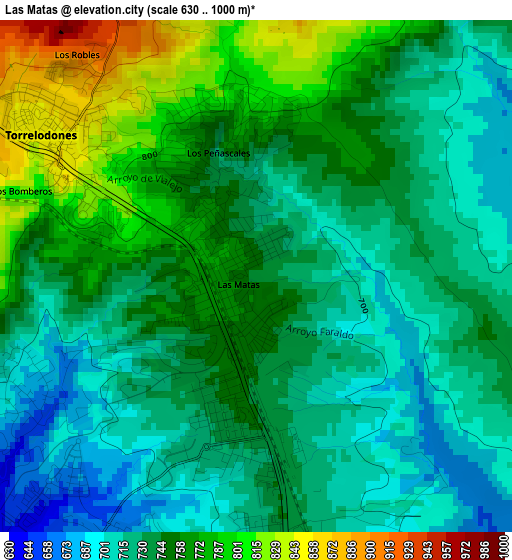
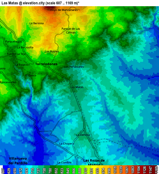
Below is the Elevation map of Las Matas, which displays elevation range with different colors. Scale of the first map is from 630 to 1000 m (2067 to 3281 ft) with average elevation of 742.2 meters (=2435 ft) [note 1]
These maps also provides idea of topography and contour of this city, they are displayed at different zoom levels. More info about maps, scale and edge coordinates you can find below images.
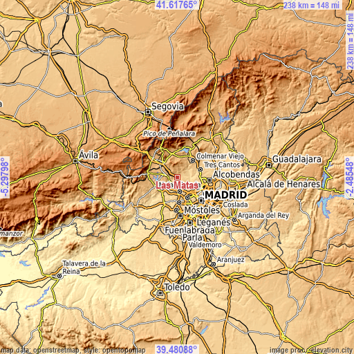
| \ | Map #1 | Map #2 | Topo.Map |
| Scale [m] | 630..1000 m | 607..1169 m | × |
| Scale [ft] | 2067..3281 ft | 1991..3835 ft | × |
| Average | 742.2 m = 2435 ft | 757.6 m = 2486 ft | × |
| Width | 7.42 km = 4.6 mi | 14.85 km = 9.2 mi | 237.6 km = 147.6 mi |
| Height | 7.42 km = 4.6 mi | 14.85 km = 9.2 mi | 237.6 km = 147.6 mi |
| ↑Max Latitude | 40.591169° | 40.624532° | 41.61765° |
| Latitude at center | 40.55779° | 40.55779° | 40.55779° |
| ↓Min Latitude | 40.524394° | 40.490982° | 39.48088° |
| ← Min Longitude | -3.935675° | -3.979621° | -5.29798° |
| Longitude center | -3.89173° | -3.89173° | -3.89173° |
| →Max Longitude | -3.847785° | -3.803839° | -2.48548° |
Nearby cities:
Cities around Las Matas sort by population:
• Fuencarral-El Pardo elevation 687 m
15.1 km,  115°
115°
• Las Rozas de Madrid 718 m
7.4 km,  168°
168°
• Majadahonda 743 m
9.5 km, 169°
• Collado-Villalba 884 m
12.8 km,  311°
311°
• Galapagar 883 m
9.8 km,  283°
283°
• Torrelodones 856 m
3.6 km, 305°
• Villanueva del Pardillo 654 m
9.7 km,  219°
219°
• Moralzarzal 975 m
15 km,  333°
333°
• Colmenarejo 871 m
10.6 km,  271°
271°
• Hoyo de Manzanares 1005 m
7.3 km,  349°
349°
• El Pardo 609 m
11.2 km, 115°
• Navalquejigo 889 m
14.4 km,  292°
292°
Multilingual:
 En español:
Las Matas elevación 736 m.
 En France:
Las Matas élévation 736 m.
 Auf Deutsch:
Las Matas höhe über dem Meeresspiegel ist 736 m.

Sources and notes:
- [note 1] Map square and city borders are not equal. Map elevation data is calculated only from area inside that square.
- [src 1] Elevation data from geonames database provided with same terms of usage.
- [src 2] The elevation map of Las Matas is generated using elevation data from NASA's 3 arcsec (90m) resolution SRTM data.
- [src 3] Base (background) map © OpenStreetMap contributors tiles are generated by Geofabrik and OpenTopoMap.
Copyright & License:
This Las Matas Elevation Map is licensed under CC BY-SA. You may reuse any part from this page, if you give a proper credit by linking to this URL:
 More info on terms of use page.