El Pardo elevation
El Pardo (Madrid, Provincia de Madrid), Spain elevation is 609 meters and El Pardo elevation in feet is 1998 ft above sea level [src 1]. El Pardo is a populated place (feature code) with elevation that is 6 meters (20 ft) bigger than average city elevation in Spain.
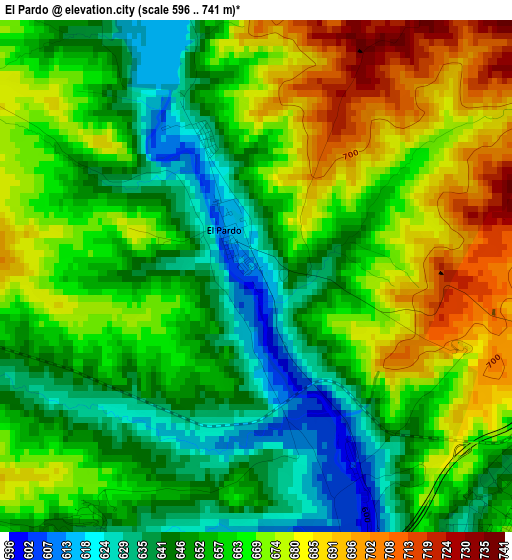
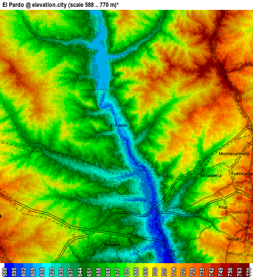
Below is the Elevation map of El Pardo, which displays elevation range with different colors. Scale of the first map is from 596 to 741 m (1955 to 2431 ft) with average elevation of 660.9 meters (=2168 ft) [note 1]
These maps also provides idea of topography and contour of this city, they are displayed at different zoom levels. More info about maps, scale and edge coordinates you can find below images.
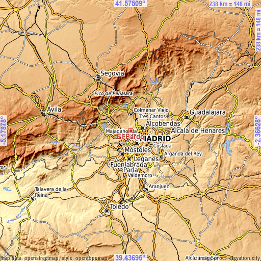
| \ | Map #1 | Map #2 | Topo.Map |
| Scale [m] | 596..741 m | 588..770 m | × |
| Scale [ft] | 1955..2431 ft | 1929..2526 ft | × |
| Average | 660.9 m = 2168 ft | 680.7 m = 2233 ft | × |
| Width | 7.43 km = 4.6 mi | 14.86 km = 9.2 mi | 237.7 km = 147.7 mi |
| Height | 7.43 km = 4.6 mi | 14.86 km = 9.2 mi | 237.7 km = 147.7 mi |
| ↑Max Latitude | 40.547941° | 40.581325° | 41.57509° |
| Latitude at center | 40.51454° | 40.51454° | 40.51454° |
| ↓Min Latitude | 40.481123° | 40.447689° | 39.43695° |
| ← Min Longitude | -3.816475° | -3.860421° | -5.17878° |
| Longitude center | -3.77253° | -3.77253° | -3.77253° |
| →Max Longitude | -3.728585° | -3.684639° | -2.36628° |
Nearby cities:
Cities around El Pardo sort by population:
• Fuencarral-El Pardo elevation 687 m
3.9 km,  117°
117°
• Tetuán de las Victorias 725 m
8.8 km,  133°
133°
• Chamberí 693 m
10.7 km,  146°
146°
• Chamartín 719 m
10 km, 125°
• Moncloa-Aravaca 615 m
9.4 km,  158°
158°
• Las Rozas de Madrid 718 m
8.9 km,  254°
254°
• Pozuelo de Alarcón 704 m
9.7 km,  200°
200°
• Majadahonda 743 m
9.6 km,  241°
241°
• Tres Cantos 731 m
11 km,  29°
29°
• Pinar de Chamartín 737 m
9.7 km,  114°
114°
• Las Matas 736 m
11.2 km,  295°
295°
• Las Tablas 701 m
8.5 km,  96°
96°
Multilingual:
 En español:
El Pardo elevación 609 m.
 En France:
El Pardo élévation 609 m.
 Auf Deutsch:
El Pardo höhe über dem Meeresspiegel ist 609 m.

Sources and notes:
- [note 1] Map square and city borders are not equal. Map elevation data is calculated only from area inside that square.
- [src 1] Elevation data from geonames database provided with same terms of usage.
- [src 2] The elevation map of El Pardo is generated using elevation data from NASA's 3 arcsec (90m) resolution SRTM data.
- [src 3] Base (background) map © OpenStreetMap contributors tiles are generated by Geofabrik and OpenTopoMap.
Copyright & License:
This El Pardo Elevation Map is licensed under CC BY-SA. You may reuse any part from this page, if you give a proper credit by linking to this URL:
 More info on terms of use page.