Mojados elevation
Mojados (Castille and León, Provincia de Valladolid), Spain elevation is 718 meters and Mojados elevation in feet is 2356 ft above sea level [src 1]. Mojados is a seat of a third-order administrative division (feature code) with elevation that is 115 meters (377 ft) bigger than average city elevation in Spain.
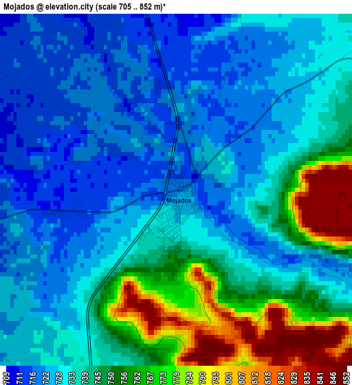
Below is the Elevation map of Mojados, which displays elevation range with different colors. Scale of the first map is from 705 to 852 m (2313 to 2795 ft) with average elevation of 739.5 meters (=2426 ft) [note 1]
These maps also provides idea of topography and contour of this city, they are displayed at different zoom levels. More info about maps, scale and edge coordinates you can find below images.
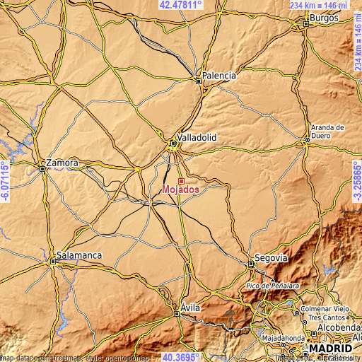
| \ | Map #1 | Topo.Map |
| Scale [m] | 705..852 m | × |
| Scale [ft] | 2313..2795 ft | × |
| Average | 739.5 m = 2426 ft | × |
| Width | 7.33 km = 4.6 mi | 234.5 km = 145.7 mi |
| Height | 7.33 km = 4.6 mi | 234.4 km = 145.6 mi |
| ↑Max Latitude | 41.465309° | 42.47811° |
| Latitude at center | 41.43237° | 41.43237° |
| ↓Min Latitude | 41.399414° | 40.3695° |
| ← Min Longitude | -4.708845° | -6.07115° |
| Longitude center | -4.6649° | -4.6649° |
| →Max Longitude | -4.620955° | -3.25865° |
Nearby cities:
Cities around Mojados sort by population:
• Iscar elevation 755 m
13.5 km,  125°
125°
• Pedrajas de San Esteban 754 m
12.2 km,  145°
145°
• Portillo 850 m
8.1 km,  50°
50°
• Boecillo 726 m
12.4 km,  346°
346°
• Aldeamayor de San Martín 708 m
9.2 km,  13°
13°
• Viana de Cega 692 m
13 km,  325°
325°
• Valdestillas 702 m
10.1 km,  299°
299°
• La Pedraja de Portillo 719 m
4.6 km,  19°
19°
• Matapozuelos 729 m
10.7 km,  259°
259°
• Alcazarén 737 m
6.9 km,  185°
185°
• Megeces 735 m
9 km,  107°
107°
• Aldea de San Miguel 742 m
5.2 km, 52°
Multilingual:
 En español:
Mojados elevación 718 m.
 En France:
Mojados élévation 718 m.


Sources and notes:
- [note 1] Map square and city borders are not equal. Map elevation data is calculated only from area inside that square.
- [src 1] Elevation data from geonames database provided with same terms of usage.
- [src 2] The elevation map of Mojados is generated using elevation data from NASA's 3 arcsec (90m) resolution SRTM data.
- [src 3] Base (background) map © OpenStreetMap contributors tiles are generated by Geofabrik and OpenTopoMap.
Copyright & License:
This Mojados Elevation Map is licensed under CC BY-SA. You may reuse any part from this page, if you give a proper credit by linking to this URL:
 More info on terms of use page.