Alcazarén elevation
Alcazarén (Castille and León, Provincia de Valladolid), Spain elevation is 737 meters and Alcazarén elevation in feet is 2418 ft above sea level [src 1]. Alcazarén is a seat of a third-order administrative division (feature code) with elevation that is 134 meters (440 ft) bigger than average city elevation in Spain.
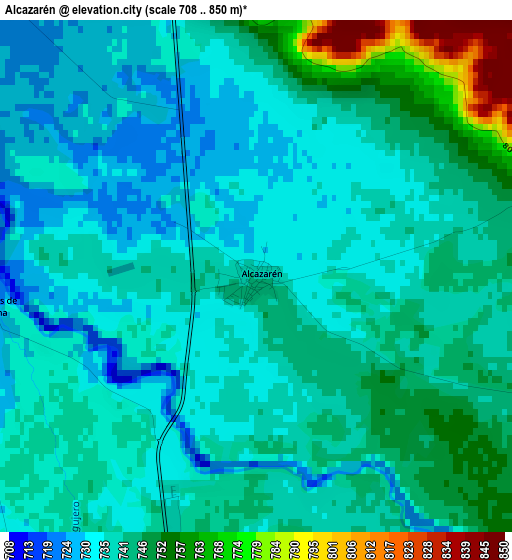
Below is the Elevation map of Alcazarén, which displays elevation range with different colors. Scale of the first map is from 708 to 850 m (2323 to 2789 ft) with average elevation of 740.3 meters (=2429 ft) [note 1]
These maps also provides idea of topography and contour of this city, they are displayed at different zoom levels. More info about maps, scale and edge coordinates you can find below images.
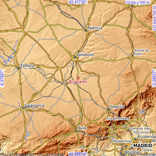
| \ | Map #1 | Topo.Map |
| Scale [m] | 708..850 m | × |
| Scale [ft] | 2323..2789 ft | × |
| Average | 740.3 m = 2429 ft | × |
| Width | 7.33 km = 4.6 mi | 234.7 km = 145.8 mi |
| Height | 7.33 km = 4.6 mi | 234.7 km = 145.8 mi |
| ↑Max Latitude | 41.40358° | 42.41736° |
| Latitude at center | 41.37061° | 41.37061° |
| ↓Min Latitude | 41.337623° | 40.30674° |
| ← Min Longitude | -4.716565° | -6.07887° |
| Longitude center | -4.67262° | -4.67262° |
| →Max Longitude | -4.628675° | -3.26637° |
Nearby cities:
Cities around Alcazarén sort by population:
• Iscar elevation 755 m
11.7 km,  95°
95°
• Olmedo 767 m
9.4 km,  188°
188°
• Pedrajas de San Esteban 754 m
8.2 km,  113°
113°
• Mojados 718 m
6.9 km,  5°
5°
• Portillo 850 m
13.9 km,  29°
29°
• La Pedraja de Portillo 719 m
11.4 km, 11°
• Matapozuelos 729 m
11 km,  296°
296°
• Megeces 735 m
10.2 km,  65°
65°
• Aldea de San Miguel 742 m
11.1 km, 25°
• Ventosa de la Cuesta 765 m
13.8 km,  289°
289°
• Llano de Olmedo 781 m
12.5 km,  156°
156°
• Aguasal 755 m
10.8 km,  171°
171°
Multilingual:
 En español:
Alcazarén elevación 737 m.
 En France:
Alcazarén élévation 737 m.
 Auf Deutsch:
Alcazarén höhe über dem Meeresspiegel ist 737 m.

Sources and notes:
- [note 1] Map square and city borders are not equal. Map elevation data is calculated only from area inside that square.
- [src 1] Elevation data from geonames database provided with same terms of usage.
- [src 2] The elevation map of Alcazarén is generated using elevation data from NASA's 3 arcsec (90m) resolution SRTM data.
- [src 3] Base (background) map © OpenStreetMap contributors tiles are generated by Geofabrik and OpenTopoMap.
Copyright & License:
This Alcazarén Elevation Map is licensed under CC BY-SA. You may reuse any part from this page, if you give a proper credit by linking to this URL:
 More info on terms of use page.