Viana de Cega elevation
Viana de Cega (Castille and León, Provincia de Valladolid), Spain elevation is 692 meters and Viana de Cega elevation in feet is 2270 ft above sea level [src 1]. Viana de Cega is a seat of a third-order administrative division (feature code) with elevation that is 89 meters (292 ft) bigger than average city elevation in Spain.
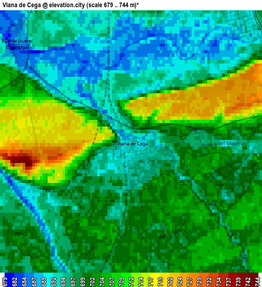
Below is the Elevation map of Viana de Cega, which displays elevation range with different colors. Scale of the first map is from 679 to 744 m (2228 to 2441 ft) with average elevation of 699.9 meters (=2296 ft) [note 1]
These maps also provides idea of topography and contour of this city, they are displayed at different zoom levels. More info about maps, scale and edge coordinates you can find below images.
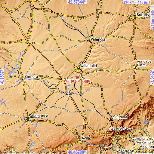
| \ | Map #1 | Topo.Map |
| Scale [m] | 679..744 m | × |
| Scale [ft] | 2228..2441 ft | × |
| Average | 699.9 m = 2296 ft | × |
| Width | 7.32 km = 4.5 mi | 234.1 km = 145.5 mi |
| Height | 7.32 km = 4.5 mi | 234.1 km = 145.5 mi |
| ↑Max Latitude | 41.56216° | 42.57344° |
| Latitude at center | 41.52927° | 41.52927° |
| ↓Min Latitude | 41.496363° | 40.46798° |
| ← Min Longitude | -4.796395° | -6.1587° |
| Longitude center | -4.75245° | -4.75245° |
| →Max Longitude | -4.708505° | -3.3462° |
Nearby cities:
Cities around Viana de Cega sort by population:
• Laguna de Duero elevation 708 m
6.3 km,  22°
22°
• Arroyo de la Encomienda 691 m
9.7 km,  337°
337°
• Cistérniga 743 m
10.8 km,  30°
30°
• Simancas 720 m
9.3 km,  317°
317°
• Mojados 718 m
13 km,  145°
145°
• Boecillo 726 m
4.6 km,  73°
73°
• Aldeamayor de San Martín 708 m
9.6 km,  101°
101°
• Valdestillas 702 m
6 km,  194°
194°
• Serrada 725 m
12.2 km,  228°
228°
• Villanueva de Duero 693 m
9.6 km,  263°
263°
• La Pedraja de Portillo 719 m
10.9 km,  126°
126°
• Geria 721 m
11.7 km,  297°
297°
Multilingual:
 En español:
Viana de Cega elevación 692 m.
 En France:
Viana de Cega élévation 692 m.
 Auf Deutsch:
Viana de Cega höhe über dem Meeresspiegel ist 692 m.

Sources and notes:
- [note 1] Map square and city borders are not equal. Map elevation data is calculated only from area inside that square.
- [src 1] Elevation data from geonames database provided with same terms of usage.
- [src 2] The elevation map of Viana de Cega is generated using elevation data from NASA's 3 arcsec (90m) resolution SRTM data.
- [src 3] Base (background) map © OpenStreetMap contributors tiles are generated by Geofabrik and OpenTopoMap.
Copyright & License:
This Viana de Cega Elevation Map is licensed under CC BY-SA. You may reuse any part from this page, if you give a proper credit by linking to this URL:
 More info on terms of use page.