Negreira elevation
Negreira (Galicia, Provincia da Coruña), Spain elevation is 178 meters and Negreira elevation in feet is 584 ft above sea level [src 1]. Negreira is a populated place (feature code) with elevation that is 425 meters (1394 ft) smaller than average city elevation in Spain.
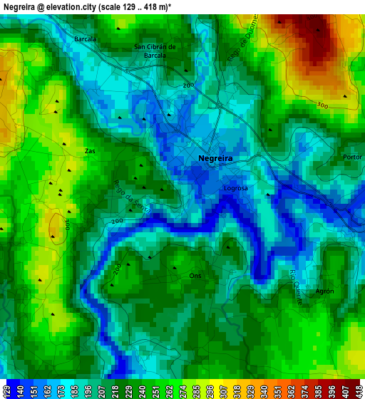
Below is the Elevation map of Negreira, which displays elevation range with different colors. Scale of the first map is from 129 to 418 m (423 to 1371 ft) with average elevation of 224 meters (=735 ft) [note 1]
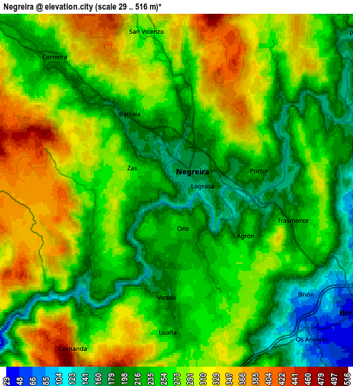
These maps also provides idea of topography and contour of this city, they are displayed at different zoom levels. More info about maps, scale and edge coordinates you can find below images.
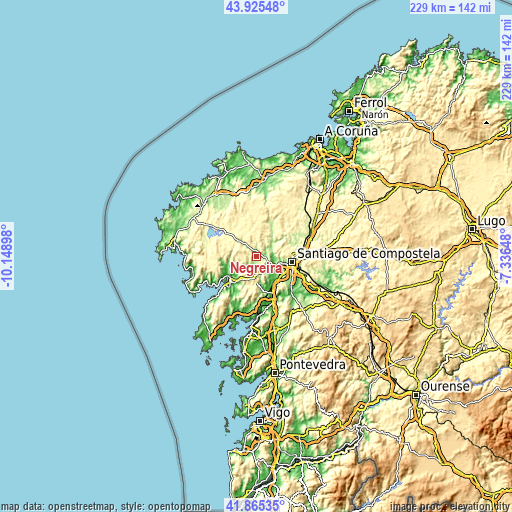
| \ | Map #1 | Map #2 | Topo.Map |
| Scale [m] | 129..418 m | 29..516 m | × |
| Scale [ft] | 423..1371 ft | 95..1693 ft | × |
| Average | 224 m = 735 ft | 258.1 m = 847 ft | × |
| Width | 7.16 km = 4.4 mi | 14.32 km = 8.9 mi | 229.1 km = 142.4 mi |
| Height | 7.16 km = 4.4 mi | 14.32 km = 8.9 mi | 229.1 km = 142.4 mi |
| ↑Max Latitude | 42.936201° | 42.968366° | 43.92548° |
| Latitude at center | 42.90402° | 42.90402° | 42.90402° |
| ↓Min Latitude | 42.871822° | 42.839607° | 41.86535° |
| ← Min Longitude | -8.786675° | -8.830621° | -10.14898° |
| Longitude center | -8.74273° | -8.74273° | -8.74273° |
| →Max Longitude | -8.698785° | -8.654839° | -7.33648° |
Nearby cities:
Cities around Negreira sort by population:
• Santiago de Compostela elevation 257 m
16.3 km,  99°
99°
• Amés 113 m
7.1 km,  89°
89°
• Santa Comba 384 m
15.3 km,  339°
339°
• Padrón 13 m
19.6 km,  159°
159°
• Outes 57 m
13.8 km,  250°
250°
• Valga 75 m
24.4 km, 159°
• Mazaricos 363 m
19.1 km,  282°
282°
• Lousame 147 m
17.8 km,  209°
209°
• Trazo 307 m
21.1 km,  53°
53°
• A Baña 324 m
6.5 km,  349°
349°
• Noia 20 m
17.7 km,  221°
221°
• Rois 87 m
16 km,  168°
168°
Multilingual:
 En español:
Negreira elevación 178 m.
 En France:
Negreira élévation 178 m.
 Auf Deutsch:
Negreira höhe über dem Meeresspiegel ist 178 m.

Sources and notes:
- [note 1] Map square and city borders are not equal. Map elevation data is calculated only from area inside that square.
- [src 1] Elevation data from geonames database provided with same terms of usage.
- [src 2] The elevation map of Negreira is generated using elevation data from NASA's 3 arcsec (90m) resolution SRTM data.
- [src 3] Base (background) map © OpenStreetMap contributors tiles are generated by Geofabrik and OpenTopoMap.
Copyright & License:
This Negreira Elevation Map is licensed under CC BY-SA. You may reuse any part from this page, if you give a proper credit by linking to this URL:
 More info on terms of use page.