Trazo elevation
Trazo (Galicia, Provincia da Coruña), Spain elevation is 307 meters and Trazo elevation in feet is 1007 ft above sea level [src 1]. Trazo is a seat of a third-order administrative division (feature code) with elevation that is 296 meters (971 ft) smaller than average city elevation in Spain.
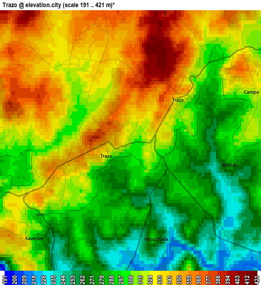
Below is the Elevation map of Trazo, which displays elevation range with different colors. Scale of the first map is from 191 to 421 m (627 to 1381 ft) with average elevation of 311.6 meters (=1022 ft) [note 1]
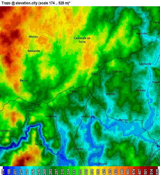
These maps also provides idea of topography and contour of this city, they are displayed at different zoom levels. More info about maps, scale and edge coordinates you can find below images.
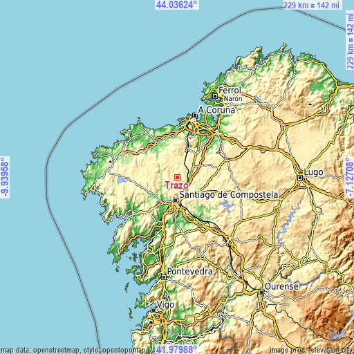
| \ | Map #1 | Map #2 | Topo.Map |
| Scale [m] | 191..421 m | 174..528 m | × |
| Scale [ft] | 627..1381 ft | 571..1732 ft | × |
| Average | 311.6 m = 1022 ft | 317.1 m = 1040 ft | × |
| Width | 7.15 km = 4.4 mi | 14.29 km = 8.9 mi | 228.6 km = 142 mi |
| Height | 7.15 km = 4.4 mi | 14.29 km = 8.9 mi | 228.6 km = 142 mi |
| ↑Max Latitude | 43.048792° | 43.080898° | 44.03624° |
| Latitude at center | 43.01667° | 43.01667° | 43.01667° |
| ↓Min Latitude | 42.984531° | 42.952375° | 41.97988° |
| ← Min Longitude | -8.577275° | -8.621221° | -9.93958° |
| Longitude center | -8.53333° | -8.53333° | -8.53333° |
| →Max Longitude | -8.489385° | -8.445439° | -7.12708° |
Nearby cities:
Cities around Trazo sort by population:
• Santiago de Compostela elevation 257 m
15.2 km,  183°
183°
• Carballo 111 m
25.3 km,  329°
329°
• Amés 113 m
16 km,  218°
218°
• Ordes 277 m
12.1 km,  56°
56°
• Santa Comba 384 m
22.5 km,  274°
274°
• Negreira 178 m
21.1 km,  233°
233°
• Oroso 274 m
8.9 km,  114°
114°
• Touro 325 m
24.7 km,  131°
131°
• A Baña 324 m
19.3 km,  251°
251°
• Mesia 378 m
23.6 km,  66°
66°
• Frades 361 m
19.8 km,  79°
79°
• Cerceda 365 m
19 km,  12°
12°
Multilingual:
 En español:
Trazo elevación 307 m.
 En France:
Trazo élévation 307 m.


Sources and notes:
- [note 1] Map square and city borders are not equal. Map elevation data is calculated only from area inside that square.
- [src 1] Elevation data from geonames database provided with same terms of usage.
- [src 2] The elevation map of Trazo is generated using elevation data from NASA's 3 arcsec (90m) resolution SRTM data.
- [src 3] Base (background) map © OpenStreetMap contributors tiles are generated by Geofabrik and OpenTopoMap.
Copyright & License:
This Trazo Elevation Map is licensed under CC BY-SA. You may reuse any part from this page, if you give a proper credit by linking to this URL:
 More info on terms of use page.