Santa Comba elevation
Santa Comba (Galicia, Provincia da Coruña), Spain elevation is 384 meters and Santa Comba elevation in feet is 1260 ft above sea level [src 1]. Santa Comba is a seat of a third-order administrative division (feature code) with elevation that is 219 meters (719 ft) smaller than average city elevation in Spain.
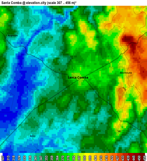
Below is the Elevation map of Santa Comba, which displays elevation range with different colors. Scale of the first map is from 307 to 456 m (1007 to 1496 ft) with average elevation of 357 meters (=1171 ft) [note 1]
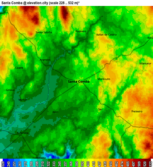
These maps also provides idea of topography and contour of this city, they are displayed at different zoom levels. More info about maps, scale and edge coordinates you can find below images.
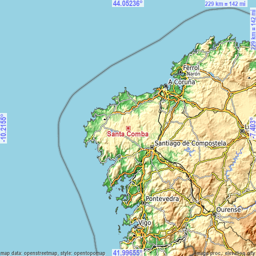
| \ | Map #1 | Map #2 | Topo.Map |
| Scale [m] | 307..456 m | 228..532 m | × |
| Scale [ft] | 1007..1496 ft | 748..1745 ft | × |
| Average | 357 m = 1171 ft | 372.3 m = 1221 ft | × |
| Width | 7.14 km = 4.4 mi | 14.29 km = 8.9 mi | 228.6 km = 142 mi |
| Height | 7.14 km = 4.4 mi | 14.29 km = 8.9 mi | 228.6 km = 142 mi |
| ↑Max Latitude | 43.065174° | 43.097271° | 44.05236° |
| Latitude at center | 43.03306° | 43.03306° | 43.03306° |
| ↓Min Latitude | 43.000929° | 42.968782° | 41.99655° |
| ← Min Longitude | -8.853195° | -8.897141° | -10.2155° |
| Longitude center | -8.80925° | -8.80925° | -8.80925° |
| →Max Longitude | -8.765305° | -8.721359° | -7.403° |
Nearby cities:
Cities around Santa Comba sort by population:
• Carballo elevation 111 m
22.2 km,  25°
25°
• Amés 113 m
19 km,  138°
138°
• Outes 57 m
20.5 km,  201°
201°
• Coristanco 134 m
19.2 km,  14°
14°
• Negreira 178 m
15.3 km,  159°
159°
• Mazaricos 363 m
16.8 km,  232°
232°
• Dumbría 200 m
24.9 km,  263°
263°
• Trazo 307 m
22.5 km,  94°
94°
• A Baña 324 m
9 km,  152°
152°
• Laxe 26 m
26.2 km,  322°
322°
• Vimianzo 136 m
20.1 km,  295°
295°
• Zas 225 m
11.3 km,  310°
310°
Multilingual:
 En español:
Santa Comba elevación 384 m.
 En France:
Santa Comba élévation 384 m.
 Auf Deutsch:
Santa Comba höhe über dem Meeresspiegel ist 384 m.

Sources and notes:
- [note 1] Map square and city borders are not equal. Map elevation data is calculated only from area inside that square.
- [src 1] Elevation data from geonames database provided with same terms of usage.
- [src 2] The elevation map of Santa Comba is generated using elevation data from NASA's 3 arcsec (90m) resolution SRTM data.
- [src 3] Base (background) map © OpenStreetMap contributors tiles are generated by Geofabrik and OpenTopoMap.
Copyright & License:
This Santa Comba Elevation Map is licensed under CC BY-SA. You may reuse any part from this page, if you give a proper credit by linking to this URL:
 More info on terms of use page.