Rascafría elevation
Rascafría (Madrid, Provincia de Madrid), Spain elevation is 1158 meters and Rascafría elevation in feet is 3799 ft above sea level [src 1]. Rascafría is a seat of a third-order administrative division (feature code) with elevation that is 555 meters (1821 ft) bigger than average city elevation in Spain.
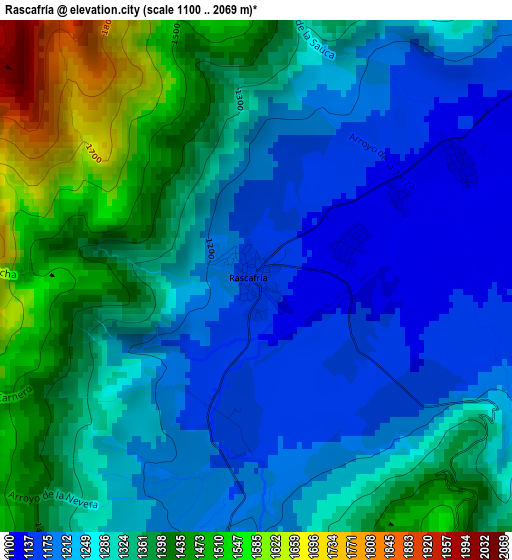
Below is the Elevation map of Rascafría, which displays elevation range with different colors. Scale of the first map is from 1100 to 2069 m (3609 to 6788 ft) with average elevation of 1304.2 meters (=4279 ft) [note 1]
These maps also provides idea of topography and contour of this city, they are displayed at different zoom levels. More info about maps, scale and edge coordinates you can find below images.
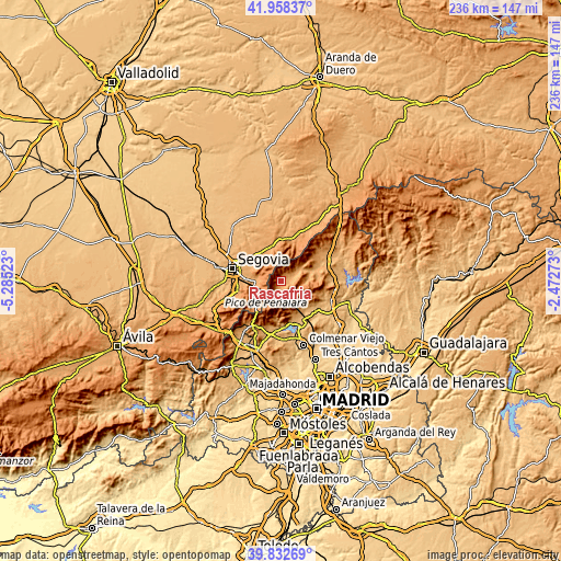
| \ | Map #1 | Topo.Map |
| Scale [m] | 1100..2069 m | × |
| Scale [ft] | 3609..6788 ft | × |
| Average | 1304.2 m = 4279 ft | × |
| Width | 7.39 km = 4.6 mi | 236.4 km = 146.9 mi |
| Height | 7.39 km = 4.6 mi | 236.3 km = 146.8 mi |
| ↑Max Latitude | 40.937276° | 41.95837° |
| Latitude at center | 40.90407° | 40.90407° |
| ↓Min Latitude | 40.870847° | 39.83269° |
| ← Min Longitude | -3.922925° | -5.28523° |
| Longitude center | -3.87898° | -3.87898° |
| →Max Longitude | -3.835035° | -2.47273° |
Nearby cities:
Cities around Rascafría sort by population:
• San Ildefonso elevation 1166 m
10.7 km,  268°
268°
• Miraflores de la Sierra 1143 m
13.9 km,  135°
135°
• Palazuelos de Eresma 1084 m
15.6 km,  280°
280°
• Bustarviejo 1197 m
15.3 km,  109°
109°
• Torrecaballeros 1160 m
15.7 km,  308°
308°
• Lozoya 1102 m
9 km,  55°
55°
• Canencia 1172 m
12.1 km,  88°
88°
• Trescasas 1131 m
14.8 km,  296°
296°
• Alameda del Valle 1111 m
3.5 km, 62°
• Pinilla del Valle 1088 m
5.7 km,  66°
66°
• Collado Hermoso 1226 m
15.3 km,  347°
347°
• Sotosalbos 1165 m
15.5 km,  340°
340°
Multilingual:
 En español:
Rascafría elevación 1158 m.
 En France:
Rascafría élévation 1158 m.
 Auf Deutsch:
Rascafría höhe über dem Meeresspiegel ist 1158 m.

Sources and notes:
- [note 1] Map square and city borders are not equal. Map elevation data is calculated only from area inside that square.
- [src 1] Elevation data from geonames database provided with same terms of usage.
- [src 2] The elevation map of Rascafría is generated using elevation data from NASA's 3 arcsec (90m) resolution SRTM data.
- [src 3] Base (background) map © OpenStreetMap contributors tiles are generated by Geofabrik and OpenTopoMap.
Copyright & License:
This Rascafría Elevation Map is licensed under CC BY-SA. You may reuse any part from this page, if you give a proper credit by linking to this URL:
 More info on terms of use page.