Lozoya elevation
Lozoya (Madrid, Provincia de Madrid), Spain elevation is 1102 meters and Lozoya elevation in feet is 3615 ft above sea level [src 1]. Lozoya is a seat of a third-order administrative division (feature code) with elevation that is 499 meters (1637 ft) bigger than average city elevation in Spain.
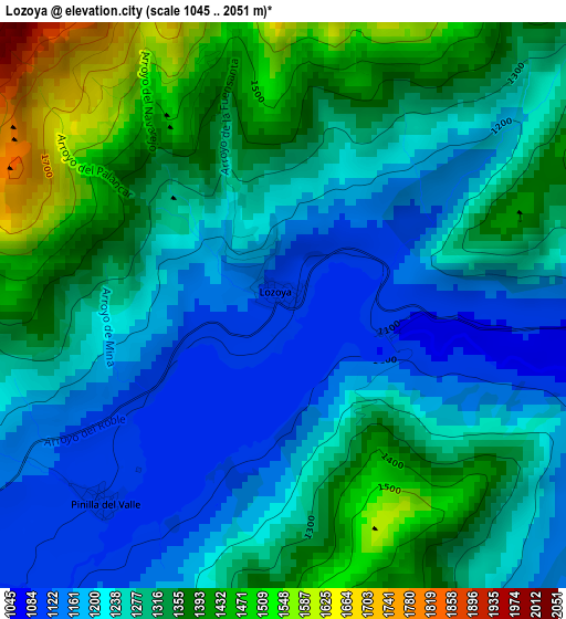
Below is the Elevation map of Lozoya, which displays elevation range with different colors. Scale of the first map is from 1045 to 2051 m (3428 to 6729 ft) with average elevation of 1281.3 meters (=4204 ft) [note 1]
These maps also provides idea of topography and contour of this city, they are displayed at different zoom levels. More info about maps, scale and edge coordinates you can find below images.
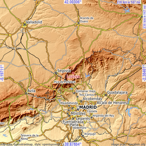
| \ | Map #1 | Topo.Map |
| Scale [m] | 1045..2051 m | × |
| Scale [ft] | 3428..6729 ft | × |
| Average | 1281.3 m = 4204 ft | × |
| Width | 7.38 km = 4.6 mi | 236.2 km = 146.8 mi |
| Height | 7.38 km = 4.6 mi | 236.2 km = 146.8 mi |
| ↑Max Latitude | 40.982673° | 42.00306° |
| Latitude at center | 40.94949° | 40.94949° |
| ↓Min Latitude | 40.91629° | 39.87884° |
| ← Min Longitude | -3.834805° | -5.19711° |
| Longitude center | -3.79086° | -3.79086° |
| →Max Longitude | -3.746915° | -2.38461° |
Nearby cities:
Cities around Lozoya sort by population:
• Buitrago del Lozoya elevation 973 m
14 km,  70°
70°
• Bustarviejo 1197 m
12.4 km,  145°
145°
• Rascafría 1158 m
9 km,  235°
235°
• Valdemanco 1134 m
14.2 km,  128°
128°
• Canencia 1172 m
6.6 km,  135°
135°
• Garganta de los Montes 1155 m
9.6 km,  110°
110°
• Navafría 1201 m
12.1 km,  346°
346°
• Alameda del Valle 1111 m
5.5 km,  231°
231°
• Villavieja del Lozoya 1040 m
11.9 km,  59°
59°
• Gascones 1049 m
14.6 km, 58°
• Pinilla del Valle 1088 m
3.5 km,  218°
218°
• Gallegos 1237 m
14 km,  1°
1°
Multilingual:
 En español:
Lozoya elevación 1102 m.
 En France:
Lozoya élévation 1102 m.


Sources and notes:
- [note 1] Map square and city borders are not equal. Map elevation data is calculated only from area inside that square.
- [src 1] Elevation data from geonames database provided with same terms of usage.
- [src 2] The elevation map of Lozoya is generated using elevation data from NASA's 3 arcsec (90m) resolution SRTM data.
- [src 3] Base (background) map © OpenStreetMap contributors tiles are generated by Geofabrik and OpenTopoMap.
Copyright & License:
This Lozoya Elevation Map is licensed under CC BY-SA. You may reuse any part from this page, if you give a proper credit by linking to this URL:
 More info on terms of use page.