Canencia elevation
Canencia (Madrid, Provincia de Madrid), Spain elevation is 1172 meters and Canencia elevation in feet is 3845 ft above sea level [src 1]. Canencia is a seat of a third-order administrative division (feature code) with elevation that is 569 meters (1867 ft) bigger than average city elevation in Spain.
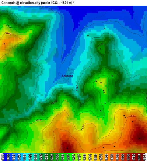
Below is the Elevation map of Canencia, which displays elevation range with different colors. Scale of the first map is from 1033 to 1821 m (3389 to 5974 ft) with average elevation of 1313.8 meters (=4310 ft) [note 1]
These maps also provides idea of topography and contour of this city, they are displayed at different zoom levels. More info about maps, scale and edge coordinates you can find below images.
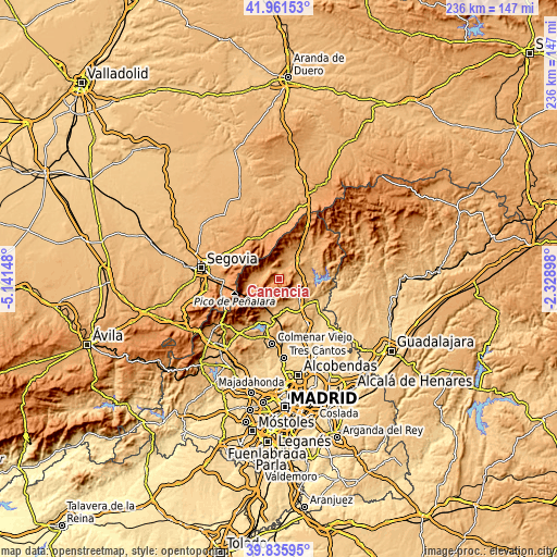
| \ | Map #1 | Topo.Map |
| Scale [m] | 1033..1821 m | × |
| Scale [ft] | 3389..5974 ft | × |
| Average | 1313.8 m = 4310 ft | × |
| Width | 7.39 km = 4.6 mi | 236.3 km = 146.8 mi |
| Height | 7.39 km = 4.6 mi | 236.3 km = 146.8 mi |
| ↑Max Latitude | 40.940484° | 41.96153° |
| Latitude at center | 40.90728° | 40.90728° |
| ↓Min Latitude | 40.874059° | 39.83595° |
| ← Min Longitude | -3.779175° | -5.14148° |
| Longitude center | -3.73523° | -3.73523° |
| →Max Longitude | -3.691285° | -2.32898° |
Nearby cities:
Cities around Canencia sort by population:
• Miraflores de la Sierra elevation 1143 m
10.5 km,  192°
192°
• La Cabrera 1033 m
11.4 km,  115°
115°
• Buitrago del Lozoya 973 m
12.6 km,  42°
42°
• Bustarviejo 1197 m
6 km,  157°
157°
• Rascafría 1158 m
12.1 km,  268°
268°
• Valdemanco 1134 m
7.6 km, 122°
• Navalafuente 898 m
11 km,  151°
151°
• Lozoya 1102 m
6.6 km,  315°
315°
• Garganta de los Montes 1155 m
4.5 km,  72°
72°
• Alameda del Valle 1111 m
9.1 km,  278°
278°
• Villavieja del Lozoya 1040 m
12.1 km,  27°
27°
• Pinilla del Valle 1088 m
7.1 km,  285°
285°
Multilingual:
 En español:
Canencia elevación 1172 m.
 En France:
Canencia élévation 1172 m.
 Auf Deutsch:
Canencia höhe über dem Meeresspiegel ist 1172 m.

Sources and notes:
- [note 1] Map square and city borders are not equal. Map elevation data is calculated only from area inside that square.
- [src 1] Elevation data from geonames database provided with same terms of usage.
- [src 2] The elevation map of Canencia is generated using elevation data from NASA's 3 arcsec (90m) resolution SRTM data.
- [src 3] Base (background) map © OpenStreetMap contributors tiles are generated by Geofabrik and OpenTopoMap.
Copyright & License:
This Canencia Elevation Map is licensed under CC BY-SA. You may reuse any part from this page, if you give a proper credit by linking to this URL:
 More info on terms of use page.