Sotosalbos elevation
Sotosalbos (Castille and León, Provincia de Segovia), Spain elevation is 1165 meters and Sotosalbos elevation in feet is 3822 ft above sea level [src 1]. Sotosalbos is a seat of a third-order administrative division (feature code) with elevation that is 562 meters (1844 ft) bigger than average city elevation in Spain.
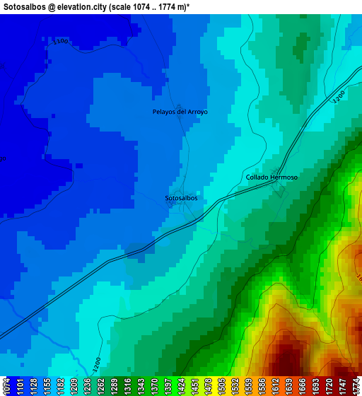
Below is the Elevation map of Sotosalbos, which displays elevation range with different colors. Scale of the first map is from 1074 to 1774 m (3524 to 5820 ft) with average elevation of 1218.6 meters (=3998 ft) [note 1]
These maps also provides idea of topography and contour of this city, they are displayed at different zoom levels. More info about maps, scale and edge coordinates you can find below images.
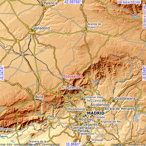
| \ | Map #1 | Topo.Map |
| Scale [m] | 1074..1774 m | × |
| Scale [ft] | 3524..5820 ft | × |
| Average | 1218.6 m = 3998 ft | × |
| Width | 7.37 km = 4.6 mi | 235.9 km = 146.6 mi |
| Height | 7.37 km = 4.6 mi | 235.9 km = 146.6 mi |
| ↑Max Latitude | 41.06851° | 42.08755° |
| Latitude at center | 41.03537° | 41.03537° |
| ↓Min Latitude | 41.002214° | 39.9661° |
| ← Min Longitude | -3.985095° | -5.3474° |
| Longitude center | -3.94115° | -3.94115° |
| →Max Longitude | -3.897205° | -2.5349° |
Nearby cities:
Cities around Sotosalbos sort by population:
• La Cuesta elevation 1123 m
5.5 km,  343°
343°
• Torrecaballeros 1160 m
8.5 km,  235°
235°
• Navafría 1201 m
10 km,  77°
77°
• Torre Val de San Pedro 1114 m
7.4 km,  52°
52°
• Basardilla 1094 m
7.2 km,  262°
262°
• Collado Hermoso 1226 m
1.9 km, 78°
• Caballar 1006 m
9.8 km,  348°
348°
• Brieva 1092 m
9.4 km,  269°
269°
• Santo Domingo de Pirón 1083 m
4.1 km,  278°
278°
• Pelayos del Arroyo 1145 m
1.7 km,  0°
0°
• Cubillo 1061 m
9.9 km,  15°
15°
• Adrada de Pirón 1022 m
9.4 km, 281°
Multilingual:
 En español:
Sotosalbos elevación 1165 m.
 En France:
Sotosalbos élévation 1165 m.
 Auf Deutsch:
Sotosalbos höhe über dem Meeresspiegel ist 1165 m.

Sources and notes:
- [note 1] Map square and city borders are not equal. Map elevation data is calculated only from area inside that square.
- [src 1] Elevation data from geonames database provided with same terms of usage.
- [src 2] The elevation map of Sotosalbos is generated using elevation data from NASA's 3 arcsec (90m) resolution SRTM data.
- [src 3] Base (background) map © OpenStreetMap contributors tiles are generated by Geofabrik and OpenTopoMap.
Copyright & License:
This Sotosalbos Elevation Map is licensed under CC BY-SA. You may reuse any part from this page, if you give a proper credit by linking to this URL:
 More info on terms of use page.