Sort elevation
Sort (Catalonia, Província de Lleida), Spain elevation is 700 meters and Sort elevation in feet is 2297 ft above sea level [src 1]. Sort is a populated place (feature code) with elevation that is 97 meters (318 ft) bigger than average city elevation in Spain.
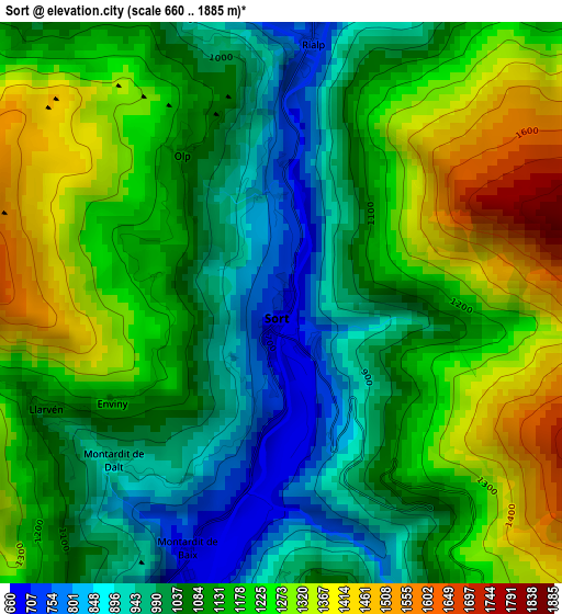
Below is the Elevation map of Sort, which displays elevation range with different colors. Scale of the first map is from 660 to 1885 m (2165 to 6184 ft) with average elevation of 1131.7 meters (=3713 ft) [note 1]
These maps also provides idea of topography and contour of this city, they are displayed at different zoom levels. More info about maps, scale and edge coordinates you can find below images.
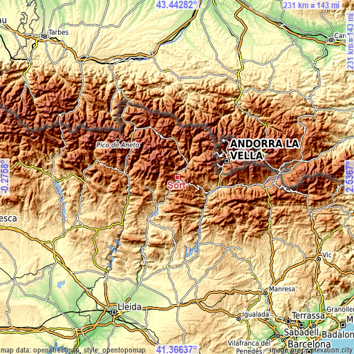
| \ | Map #1 | Topo.Map |
| Scale [m] | 660..1885 m | × |
| Scale [ft] | 2165..6184 ft | × |
| Average | 1131.7 m = 3713 ft | × |
| Width | 7.22 km = 4.5 mi | 230.9 km = 143.5 mi |
| Height | 7.21 km = 4.5 mi | 230.9 km = 143.5 mi |
| ↑Max Latitude | 42.445626° | 43.44282° |
| Latitude at center | 42.41319° | 42.41319° |
| ↓Min Latitude | 42.380737° | 41.36637° |
| ← Min Longitude | 1.086505° | -0.2758° |
| Longitude center | 1.13045° | 1.13045° |
| →Max Longitude | 1.174395° | 2.5367° |
Nearby cities:
Cities around Sort sort by population:
• La Seu d'Urgell elevation 699 m
27.8 km,  102°
102°
• Tremp 475 m
33.5 km,  215°
215°
• Oliana 460 m
41.1 km,  158°
158°
• Alàs i Cerc 910 m
32.5 km, 102°
• Coll de Nargó 582 m
30.6 km,  149°
149°
• Espot 1340 m
18.7 km,  348°
348°
• Bonansa 1244 m
38.1 km,  272°
272°
• Farrera 1355 m
14.9 km,  51°
51°
• el Pont de Bar 826 m
39.3 km, 96°
• Areny de Noguera / Arén 710 m
37.8 km,  242°
242°
• Sopeira 714 m
33.4 km,  251°
251°
• Senterada 733 m
18.7 km, 238°
Multilingual:
 En español:
Sort elevación 700 m.
 En France:
Sort élévation 700 m.


Sources and notes:
- [note 1] Map square and city borders are not equal. Map elevation data is calculated only from area inside that square.
- [src 1] Elevation data from geonames database provided with same terms of usage.
- [src 2] The elevation map of Sort is generated using elevation data from NASA's 3 arcsec (90m) resolution SRTM data.
- [src 3] Base (background) map © OpenStreetMap contributors tiles are generated by Geofabrik and OpenTopoMap.
Copyright & License:
This Sort Elevation Map is licensed under CC BY-SA. You may reuse any part from this page, if you give a proper credit by linking to this URL:
 More info on terms of use page.