Farrera elevation
Farrera (Catalonia, Província de Lleida), Spain elevation is 1355 meters and Farrera elevation in feet is 4446 ft above sea level [src 1]. Farrera is a seat of a third-order administrative division (feature code) with elevation that is 752 meters (2467 ft) bigger than average city elevation in Spain.
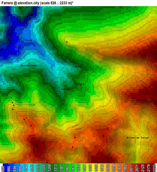
Below is the Elevation map of Farrera, which displays elevation range with different colors. Scale of the first map is from 826 to 2233 m (2710 to 7326 ft) with average elevation of 1592.1 meters (=5223 ft) [note 1]
These maps also provides idea of topography and contour of this city, they are displayed at different zoom levels. More info about maps, scale and edge coordinates you can find below images.
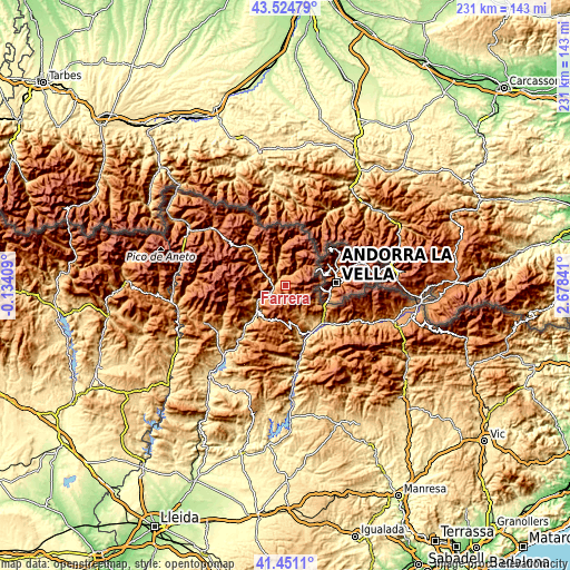
| \ | Map #1 | Topo.Map |
| Scale [m] | 826..2233 m | × |
| Scale [ft] | 2710..7326 ft | × |
| Average | 1592.1 m = 5223 ft | × |
| Width | 7.21 km = 4.5 mi | 230.6 km = 143.3 mi |
| Height | 7.21 km = 4.5 mi | 230.6 km = 143.3 mi |
| ↑Max Latitude | 42.528933° | 43.52479° |
| Latitude at center | 42.49654° | 42.49654° |
| ↓Min Latitude | 42.46413° | 41.4511° |
| ← Min Longitude | 1.228215° | -0.13409° |
| Longitude center | 1.27216° | 1.27216° |
| →Max Longitude | 1.316105° | 2.67841° |
Nearby cities:
Cities around Farrera sort by population:
• La Seu d'Urgell elevation 699 m
21.8 km,  134°
134°
• Sort 700 m
14.9 km,  231°
231°
• Éller 1440 m
43.6 km,  101°
101°
• Alàs i Cerc 910 m
25.9 km, 129°
• Toloriu 1227 m
32.8 km,  117°
117°
• Coll de Nargó 582 m
36 km,  174°
174°
• Espot 1340 m
17.7 km,  300°
300°
• Lles de Cerdanya 1476 m
36 km,  109°
109°
• Gósol 1437 m
43 km, 132°
• Meranges 1515 m
42.7 km, 97°
• Senterada 733 m
33.5 km,  235°
235°
• el Pont de Bar 826 m
30.7 km, 117°
Multilingual:
 En español:
Farrera elevación 1355 m.
 En France:
Farrera élévation 1355 m.
 Auf Deutsch:
Farrera höhe über dem Meeresspiegel ist 1355 m.

Sources and notes:
- [note 1] Map square and city borders are not equal. Map elevation data is calculated only from area inside that square.
- [src 1] Elevation data from geonames database provided with same terms of usage.
- [src 2] The elevation map of Farrera is generated using elevation data from NASA's 3 arcsec (90m) resolution SRTM data.
- [src 3] Base (background) map © OpenStreetMap contributors tiles are generated by Geofabrik and OpenTopoMap.
Copyright & License:
This Farrera Elevation Map is licensed under CC BY-SA. You may reuse any part from this page, if you give a proper credit by linking to this URL:
 More info on terms of use page.