Alàs i Cerc elevation
Alàs i Cerc (Catalonia, Província de Lleida), Spain elevation is 910 meters and Alàs i Cerc elevation in feet is 2986 ft above sea level [src 1]. Alàs i Cerc is a populated place (feature code) with elevation that is 307 meters (1007 ft) bigger than average city elevation in Spain.
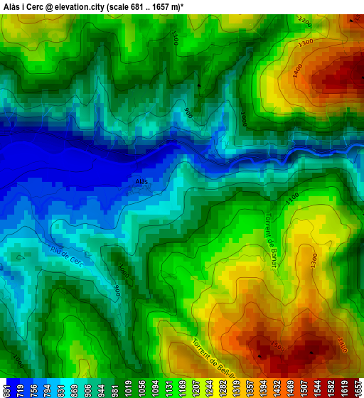
Below is the Elevation map of Alàs i Cerc, which displays elevation range with different colors. Scale of the first map is from 681 to 1657 m (2234 to 5436 ft) with average elevation of 1053.2 meters (=3455 ft) [note 1]
These maps also provides idea of topography and contour of this city, they are displayed at different zoom levels. More info about maps, scale and edge coordinates you can find below images.
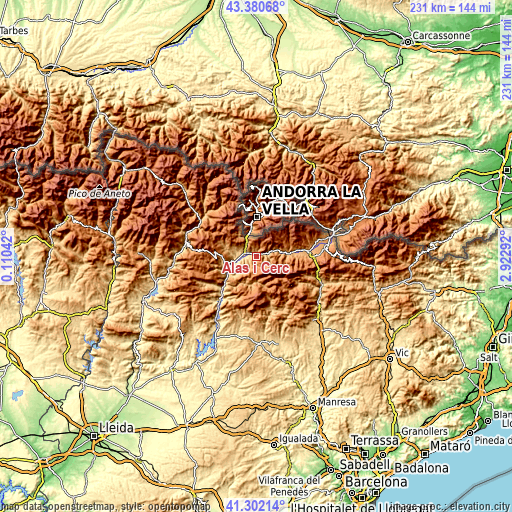
| \ | Map #1 | Topo.Map |
| Scale [m] | 681..1657 m | × |
| Scale [ft] | 2234..5436 ft | × |
| Average | 1053.2 m = 3455 ft | × |
| Width | 7.22 km = 4.5 mi | 231.1 km = 143.6 mi |
| Height | 7.22 km = 4.5 mi | 231.1 km = 143.6 mi |
| ↑Max Latitude | 42.382469° | 43.38068° |
| Latitude at center | 42.35° | 42.35° |
| ↓Min Latitude | 42.317514° | 41.30214° |
| ← Min Longitude | 1.472725° | 0.11042° |
| Longitude center | 1.51667° | 1.51667° |
| →Max Longitude | 1.560615° | 2.92292° |
Nearby cities:
Cities around Alàs i Cerc sort by population:
• La Seu d'Urgell elevation 699 m
4.6 km,  282°
282°
• Bellver de Cerdanya 1048 m
22 km,  85°
85°
• Éller 1440 m
23.8 km,  71°
71°
• Toloriu 1227 m
9.2 km,  81°
81°
• Coll de Nargó 582 m
25.5 km,  220°
220°
• Lles de Cerdanya 1476 m
14.7 km, 72°
• Gósol 1437 m
17.2 km,  136°
136°
• Riu de Cerdanya 1180 m
25.5 km, 91°
• Isòvol 1038 m
25 km, 82°
• Meranges 1515 m
24.6 km,  64°
64°
• Saldes 1365 m
22 km,  126°
126°
• el Pont de Bar 826 m
7.7 km, 72°
Multilingual:
 En español:
Alàs i Cerc elevación 910 m.
 En France:
Alàs i Cerc élévation 910 m.
 Auf Deutsch:
Alàs i Cerc höhe über dem Meeresspiegel ist 910 m.

Sources and notes:
- [note 1] Map square and city borders are not equal. Map elevation data is calculated only from area inside that square.
- [src 1] Elevation data from geonames database provided with same terms of usage.
- [src 2] The elevation map of Alàs i Cerc is generated using elevation data from NASA's 3 arcsec (90m) resolution SRTM data.
- [src 3] Base (background) map © OpenStreetMap contributors tiles are generated by Geofabrik and OpenTopoMap.
Copyright & License:
This Alàs i Cerc Elevation Map is licensed under CC BY-SA. You may reuse any part from this page, if you give a proper credit by linking to this URL:
 More info on terms of use page.