Isòvol elevation
Isòvol (Catalonia, Província de Girona), Spain elevation is 1038 meters and Isòvol elevation in feet is 3406 ft above sea level [src 1]. Isòvol is a seat of a third-order administrative division (feature code) with elevation that is 435 meters (1427 ft) bigger than average city elevation in Spain.
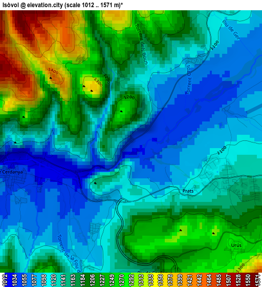
Below is the Elevation map of Isòvol, which displays elevation range with different colors. Scale of the first map is from 1012 to 1571 m (3320 to 5154 ft) with average elevation of 1163.7 meters (=3818 ft) [note 1]
These maps also provides idea of topography and contour of this city, they are displayed at different zoom levels. More info about maps, scale and edge coordinates you can find below images.
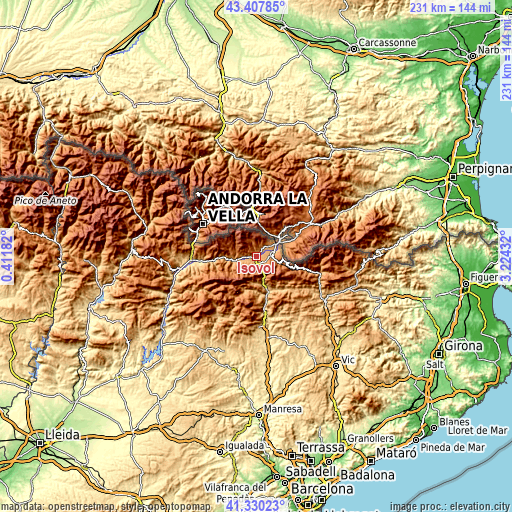
| \ | Map #1 | Topo.Map |
| Scale [m] | 1012..1571 m | × |
| Scale [ft] | 3320..5154 ft | × |
| Average | 1163.7 m = 3818 ft | × |
| Width | 7.22 km = 4.5 mi | 231 km = 143.5 mi |
| Height | 7.22 km = 4.5 mi | 231 km = 143.5 mi |
| ↑Max Latitude | 42.410085° | 43.40785° |
| Latitude at center | 42.37763° | 42.37763° |
| ↓Min Latitude | 42.345158° | 41.33023° |
| ← Min Longitude | 1.774125° | 0.41182° |
| Longitude center | 1.81807° | 1.81807° |
| →Max Longitude | 1.862015° | 3.22432° |
Nearby cities:
Cities around Isòvol sort by population:
• Puigcerdà elevation 1212 m
10.9 km,  56°
56°
• Bellver de Cerdanya 1048 m
3.1 km,  246°
246°
• Éller 1440 m
4.8 km,  333°
333°
• Lles de Cerdanya 1476 m
10.9 km,  277°
277°
• Guils de Cerdanya 1367 m
9.3 km,  33°
33°
• Meranges 1515 m
7.9 km,  341°
341°
• Bolvir 1114 m
6.8 km,  48°
48°
• Alp 1173 m
5.7 km,  95°
95°
• Das 1222 m
4.7 km,  112°
112°
• Ger 1124 m
4.3 km, 31°
• Urús 1277 m
4.1 km,  135°
135°
• Riu de Cerdanya 1180 m
3.6 km,  169°
169°
Multilingual:
 En español:
Isóbol elevación 1038 m.
 En France:
Isòvol élévation 1038 m.


Sources and notes:
- [note 1] Map square and city borders are not equal. Map elevation data is calculated only from area inside that square.
- [src 1] Elevation data from geonames database provided with same terms of usage.
- [src 2] The elevation map of Isòvol is generated using elevation data from NASA's 3 arcsec (90m) resolution SRTM data.
- [src 3] Base (background) map © OpenStreetMap contributors tiles are generated by Geofabrik and OpenTopoMap.
Copyright & License:
This Isòvol Elevation Map is licensed under CC BY-SA. You may reuse any part from this page, if you give a proper credit by linking to this URL:
 More info on terms of use page.