Sopeira elevation
Sopeira (Aragon, Provincia de Huesca), Spain elevation is 714 meters and Sopeira elevation in feet is 2343 ft above sea level [src 1]. Sopeira is a seat of a third-order administrative division (feature code) with elevation that is 111 meters (364 ft) bigger than average city elevation in Spain.
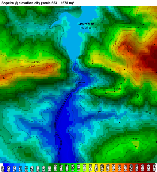
Below is the Elevation map of Sopeira, which displays elevation range with different colors. Scale of the first map is from 653 to 1678 m (2142 to 5505 ft) with average elevation of 987.4 meters (=3240 ft) [note 1]
These maps also provides idea of topography and contour of this city, they are displayed at different zoom levels. More info about maps, scale and edge coordinates you can find below images.
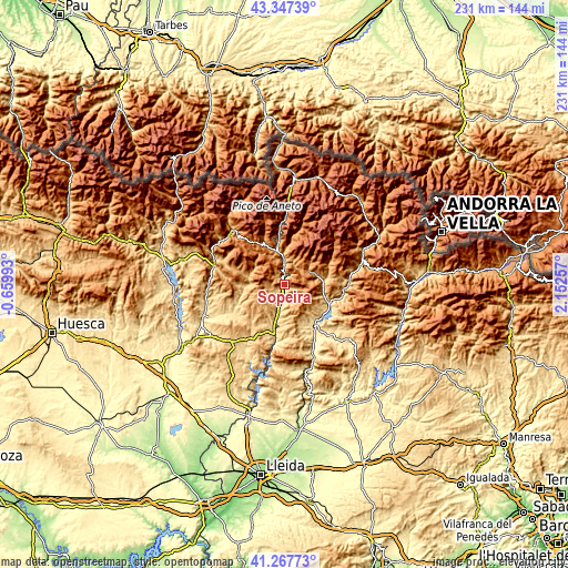
| \ | Map #1 | Topo.Map |
| Scale [m] | 653..1678 m | × |
| Scale [ft] | 2142..5505 ft | × |
| Average | 987.4 m = 3240 ft | × |
| Width | 7.23 km = 4.5 mi | 231.2 km = 143.7 mi |
| Height | 7.23 km = 4.5 mi | 231.2 km = 143.7 mi |
| ↑Max Latitude | 42.348637° | 43.34739° |
| Latitude at center | 42.31615° | 42.31615° |
| ↓Min Latitude | 42.283647° | 41.26773° |
| ← Min Longitude | 0.702375° | -0.65993° |
| Longitude center | 0.74632° | 0.74632° |
| →Max Longitude | 0.790265° | 2.15257° |
Nearby cities:
Cities around Sopeira sort by population:
• Tremp elevation 475 m
20.6 km,  143°
143°
• Castejón de Sos 919 m
30.2 km,  316°
316°
• Laspaúles 1457 m
21.2 km, 324°
• Bisaurri 1119 m
28.1 km, 315°
• Llimiana 784 m
30.3 km,  152°
152°
• Lascuarre 652 m
22.9 km,  234°
234°
• Castigaleu 835 m
18.6 km, 227°
• Bonansa 1244 m
13.9 km,  332°
332°
• Campo 691 m
30.6 km,  289°
289°
• Senterada 733 m
15.7 km,  86°
86°
• Beranuy 1335 m
13.7 km, 294°
• Areny de Noguera / Arén 710 m
6.8 km,  197°
197°
Multilingual:
 En español:
Sopeira elevación 714 m.
 En France:
Sopeira élévation 714 m.


Sources and notes:
- [note 1] Map square and city borders are not equal. Map elevation data is calculated only from area inside that square.
- [src 1] Elevation data from geonames database provided with same terms of usage.
- [src 2] The elevation map of Sopeira is generated using elevation data from NASA's 3 arcsec (90m) resolution SRTM data.
- [src 3] Base (background) map © OpenStreetMap contributors tiles are generated by Geofabrik and OpenTopoMap.
Copyright & License:
This Sopeira Elevation Map is licensed under CC BY-SA. You may reuse any part from this page, if you give a proper credit by linking to this URL:
 More info on terms of use page.