Sotresgudo elevation
Sotresgudo (Castille and León, Provincia de Burgos), Spain elevation is 872 meters and Sotresgudo elevation in feet is 2861 ft above sea level [src 1]. Sotresgudo is a seat of a third-order administrative division (feature code) with elevation that is 269 meters (883 ft) bigger than average city elevation in Spain.
Below is the Elevation map of Sotresgudo, which displays elevation range with different colors. Scale of the first map is from 835 to 949 m (2740 to 3114 ft) with average elevation of 879.1 meters (=2884 ft) [note 1]
These maps also provides idea of topography and contour of this city, they are displayed at different zoom levels. More info about maps, scale and edge coordinates you can find below images.
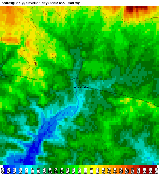
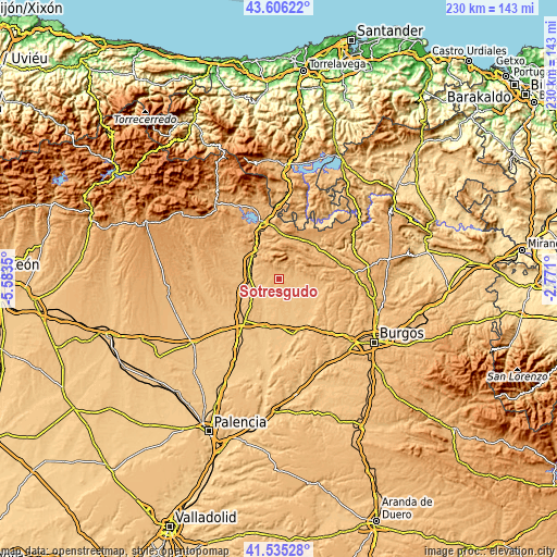
| \ | Map #1 | Topo.Map |
| Scale [m] | 835..949 m | × |
| Scale [ft] | 2740..3114 ft | × |
| Average | 879.1 m = 2884 ft | × |
| Width | 7.2 km = 4.5 mi | 230.3 km = 143.1 mi |
| Height | 7.2 km = 4.5 mi | 230.3 km = 143.1 mi |
| ↑Max Latitude | 42.6117° | 43.60622° |
| Latitude at center | 42.57935° | 42.57935° |
| ↓Min Latitude | 42.546983° | 41.53528° |
| ← Min Longitude | -4.221195° | -5.5835° |
| Longitude center | -4.17725° | -4.17725° |
| →Max Longitude | -4.133305° | -2.771° |
Nearby cities:
Cities around Sotresgudo sort by population:
• Herrera de Pisuerga elevation 849 m
12.7 km,  277°
277°
• Villadiego 841 m
15.4 km,  117°
117°
• Alar del Rey 852 m
14.3 km,  309°
309°
• Humada 958 m
12.4 km,  38°
38°
• Rebolledo de la Torre 956 m
12.9 km,  341°
341°
• Calahorra de Boedo 871 m
17 km,  268°
268°
• Padilla de Arriba 823 m
15.8 km,  184°
184°
• Villamayor de Treviño 818 m
14 km,  160°
160°
• Santa Cruz de Boedo 848 m
17.2 km,  249°
249°
• San Cristóbal de Boedo 869 m
15 km, 253°
• Sordillos 819 m
14.3 km, 156°
• Rezmondo 829 m
8.7 km,  215°
215°
Multilingual:
 En español:
Sotresgudo elevación 872 m.
 En France:
Sotresgudo élévation 872 m.
 Auf Deutsch:
Sotresgudo höhe über dem Meeresspiegel ist 872 m.

Sources and notes:
- [note 1] Map square and city borders are not equal. Map elevation data is calculated only from area inside that square.
- [src 1] Elevation data from geonames database provided with same terms of usage.
- [src 2] The elevation map of Sotresgudo is generated using elevation data from NASA's 3 arcsec (90m) resolution SRTM data.
- [src 3] Base (background) map © OpenStreetMap contributors tiles are generated by Geofabrik and OpenTopoMap.
Copyright & License:
This Sotresgudo Elevation Map is licensed under CC BY-SA. You may reuse any part from this page, if you give a proper credit by linking to this URL:
 More info on terms of use page.