Villadiego elevation
Villadiego (Castille and León, Provincia de Burgos), Spain elevation is 841 meters and Villadiego elevation in feet is 2759 ft above sea level [src 1]. Villadiego is a seat of a third-order administrative division (feature code) with elevation that is 238 meters (781 ft) bigger than average city elevation in Spain.
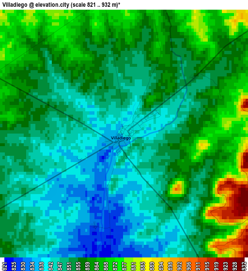
Below is the Elevation map of Villadiego, which displays elevation range with different colors. Scale of the first map is from 821 to 932 m (2694 to 3058 ft) with average elevation of 854.9 meters (=2805 ft) [note 1]
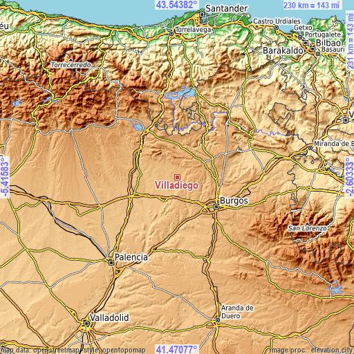
These maps also provides idea of topography and contour of this city, they are displayed at different zoom levels. More info about maps, scale and edge coordinates you can find below images.
| \ | Map #1 | Topo.Map |
| Scale [m] | 821..932 m | × |
| Scale [ft] | 2694..3058 ft | × |
| Average | 854.9 m = 2805 ft | × |
| Width | 7.2 km = 4.5 mi | 230.5 km = 143.2 mi |
| Height | 7.2 km = 4.5 mi | 230.5 km = 143.2 mi |
| ↑Max Latitude | 42.548273° | 43.54382° |
| Latitude at center | 42.51589° | 42.51589° |
| ↓Min Latitude | 42.48349° | 41.47077° |
| ← Min Longitude | -4.053525° | -5.41583° |
| Longitude center | -4.00958° | -4.00958° |
| →Max Longitude | -3.965635° | -2.60333° |
Nearby cities:
Cities around Villadiego sort by population:
• Sasamón elevation 816 m
11.3 km,  193°
193°
• Sotresgudo 872 m
15.4 km,  297°
297°
• Villanueva de Argaño 839 m
16.3 km,  157°
157°
• Grijalba 813 m
13.1 km,  223°
223°
• Susinos del Páramo 891 m
8.5 km,  125°
125°
• Villegas 825 m
5.3 km, 187°
• Padilla de Arriba 823 m
17.2 km,  239°
239°
• Pedrosa del Páramo 941 m
8.8 km, 159°
• Villamayor de Treviño 818 m
10.9 km, 235°
• Tobar 879 m
6.7 km,  121°
121°
• Sordillos 819 m
10 km,  233°
233°
• Manciles 894 m
8.4 km,  140°
140°
Multilingual:
 En español:
Villadiego elevación 841 m.
 En France:
Villadiego élévation 841 m.
 Auf Deutsch:
Villadiego höhe über dem Meeresspiegel ist 841 m.

Sources and notes:
- [note 1] Map square and city borders are not equal. Map elevation data is calculated only from area inside that square.
- [src 1] Elevation data from geonames database provided with same terms of usage.
- [src 2] The elevation map of Villadiego is generated using elevation data from NASA's 3 arcsec (90m) resolution SRTM data.
- [src 3] Base (background) map © OpenStreetMap contributors tiles are generated by Geofabrik and OpenTopoMap.
Copyright & License:
This Villadiego Elevation Map is licensed under CC BY-SA. You may reuse any part from this page, if you give a proper credit by linking to this URL:
 More info on terms of use page.