Rezmondo elevation
Rezmondo (Castille and León, Provincia de Burgos), Spain elevation is 829 meters and Rezmondo elevation in feet is 2720 ft above sea level [src 1]. Rezmondo is a seat of a third-order administrative division (feature code) with elevation that is 226 meters (741 ft) bigger than average city elevation in Spain.
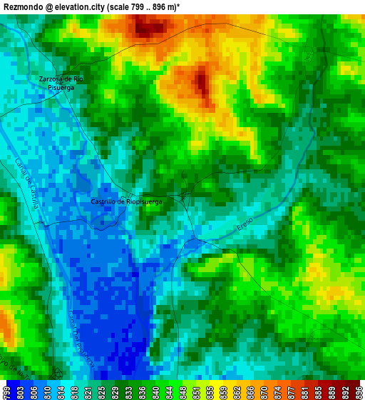
Below is the Elevation map of Rezmondo, which displays elevation range with different colors. Scale of the first map is from 799 to 896 m (2621 to 2940 ft) with average elevation of 831.8 meters (=2729 ft) [note 1]
These maps also provides idea of topography and contour of this city, they are displayed at different zoom levels. More info about maps, scale and edge coordinates you can find below images.
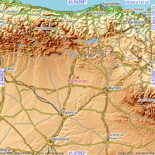
| \ | Map #1 | Topo.Map |
| Scale [m] | 799..896 m | × |
| Scale [ft] | 2621..2940 ft | × |
| Average | 831.8 m = 2729 ft | × |
| Width | 7.2 km = 4.5 mi | 230.5 km = 143.2 mi |
| Height | 7.2 km = 4.5 mi | 230.5 km = 143.2 mi |
| ↑Max Latitude | 42.548033° | 43.54358° |
| Latitude at center | 42.51565° | 42.51565° |
| ↓Min Latitude | 42.48325° | 41.47053° |
| ← Min Longitude | -4.282715° | -5.64502° |
| Longitude center | -4.23877° | -4.23877° |
| →Max Longitude | -4.194825° | -2.83252° |
Nearby cities:
Cities around Rezmondo sort by population:
• Herrera de Pisuerga elevation 849 m
11.6 km,  319°
319°
• Melgar de Fernamental 804 m
12.4 km,  182°
182°
• Sotresgudo 872 m
8.7 km,  35°
35°
• Espinosa de Villagonzalo 827 m
11.7 km,  249°
249°
• Calahorra de Boedo 871 m
13.6 km,  298°
298°
• Padilla de Abajo 799 m
13 km,  156°
156°
• Padilla de Arriba 823 m
9.5 km, 155°
• Villamayor de Treviño 818 m
11.6 km,  122°
122°
• Villaprovedo 875 m
12.9 km,  270°
270°
• Santa Cruz de Boedo 848 m
11.1 km,  275°
275°
• San Cristóbal de Boedo 869 m
9.8 km,  287°
287°
• Sordillos 819 m
12.3 km, 118°
Multilingual:
 En español:
Rezmondo elevación 829 m.
 En France:
Rezmondo élévation 829 m.
 Auf Deutsch:
Rezmondo höhe über dem Meeresspiegel ist 829 m.

Sources and notes:
- [note 1] Map square and city borders are not equal. Map elevation data is calculated only from area inside that square.
- [src 1] Elevation data from geonames database provided with same terms of usage.
- [src 2] The elevation map of Rezmondo is generated using elevation data from NASA's 3 arcsec (90m) resolution SRTM data.
- [src 3] Base (background) map © OpenStreetMap contributors tiles are generated by Geofabrik and OpenTopoMap.
Copyright & License:
This Rezmondo Elevation Map is licensed under CC BY-SA. You may reuse any part from this page, if you give a proper credit by linking to this URL:
 More info on terms of use page.