Valdemora elevation
Valdemora (Castille and León, Provincia de León), Spain elevation is 779 meters and Valdemora elevation in feet is 2556 ft above sea level [src 1]. Valdemora is a seat of a third-order administrative division (feature code) with elevation that is 176 meters (577 ft) bigger than average city elevation in Spain.
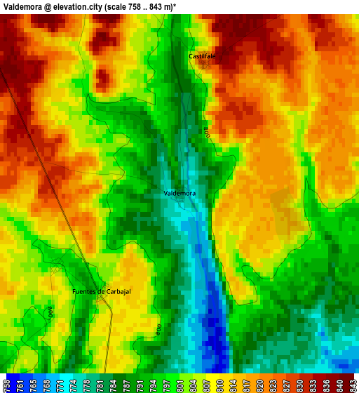
Below is the Elevation map of Valdemora, which displays elevation range with different colors. Scale of the first map is from 758 to 843 m (2487 to 2766 ft) with average elevation of 804.4 meters (=2639 ft) [note 1]
These maps also provides idea of topography and contour of this city, they are displayed at different zoom levels. More info about maps, scale and edge coordinates you can find below images.
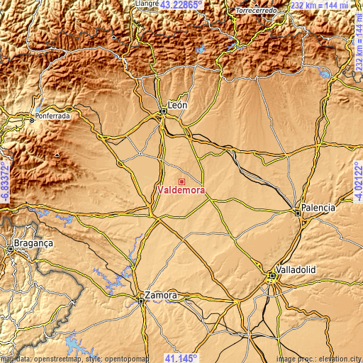
| \ | Map #1 | Topo.Map |
| Scale [m] | 758..843 m | × |
| Scale [ft] | 2487..2766 ft | × |
| Average | 804.4 m = 2639 ft | × |
| Width | 7.24 km = 4.5 mi | 231.7 km = 144 mi |
| Height | 7.24 km = 4.5 mi | 231.7 km = 144 mi |
| ↑Max Latitude | 42.227959° | 43.22865° |
| Latitude at center | 42.19541° | 42.19541° |
| ↓Min Latitude | 42.162844° | 41.145° |
| ← Min Longitude | -5.471415° | -6.83372° |
| Longitude center | -5.42747° | -5.42747° |
| →Max Longitude | -5.383525° | -4.02122° |
Nearby cities:
Cities around Valdemora sort by population:
• Valencia de Don Juan elevation 768 m
13.2 km,  325°
325°
• Valderas 755 m
13.1 km,  185°
185°
• Mayorga 780 m
13.9 km,  103°
103°
• Toral de los Guzmanes 744 m
12.7 km,  294°
294°
• Gordoncillo 753 m
7 km,  162°
162°
• Villamandos 731 m
13.8 km,  263°
263°
• Algadefe 743 m
13.2 km,  281°
281°
• Campazas 775 m
8 km,  222°
222°
• Villabraz 847 m
5.9 km,  345°
345°
• Castrobol 771 m
11.4 km,  124°
124°
• Castilfalé 828 m
2.8 km,  10°
10°
• Fuentes de Carbajal 809 m
2.5 km, 217°
Multilingual:
 En español:
Valdemora elevación 779 m.
 En France:
Valdemora élévation 779 m.
 Auf Deutsch:
Valdemora höhe über dem Meeresspiegel ist 779 m.

Sources and notes:
- [note 1] Map square and city borders are not equal. Map elevation data is calculated only from area inside that square.
- [src 1] Elevation data from geonames database provided with same terms of usage.
- [src 2] The elevation map of Valdemora is generated using elevation data from NASA's 3 arcsec (90m) resolution SRTM data.
- [src 3] Base (background) map © OpenStreetMap contributors tiles are generated by Geofabrik and OpenTopoMap.
Copyright & License:
This Valdemora Elevation Map is licensed under CC BY-SA. You may reuse any part from this page, if you give a proper credit by linking to this URL:
 More info on terms of use page.