Villamandos elevation
Villamandos (Castille and León, Provincia de León), Spain elevation is 731 meters and Villamandos elevation in feet is 2398 ft above sea level [src 1]. Villamandos is a seat of a third-order administrative division (feature code) with elevation that is 128 meters (420 ft) bigger than average city elevation in Spain.
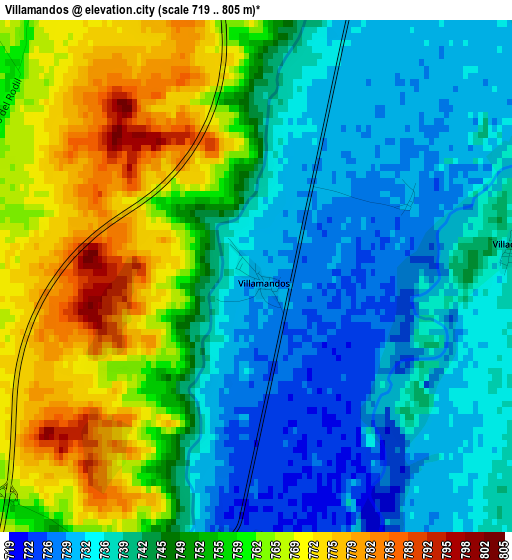
Below is the Elevation map of Villamandos, which displays elevation range with different colors. Scale of the first map is from 719 to 805 m (2359 to 2641 ft) with average elevation of 748.2 meters (=2455 ft) [note 1]
These maps also provides idea of topography and contour of this city, they are displayed at different zoom levels. More info about maps, scale and edge coordinates you can find below images.
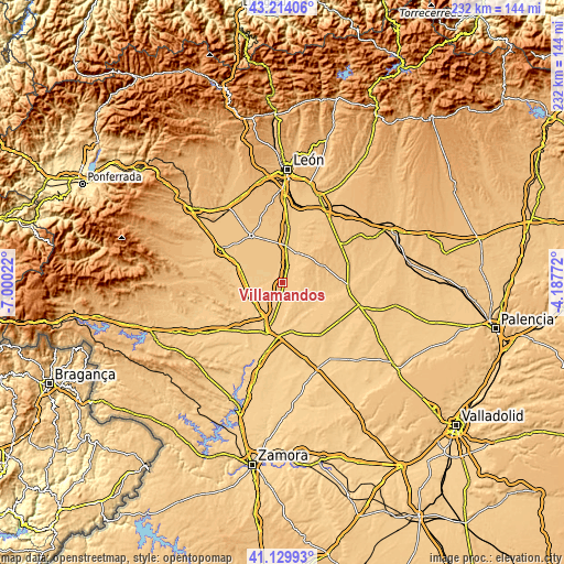
| \ | Map #1 | Topo.Map |
| Scale [m] | 719..805 m | × |
| Scale [ft] | 2359..2641 ft | × |
| Average | 748.2 m = 2455 ft | × |
| Width | 7.24 km = 4.5 mi | 231.7 km = 144 mi |
| Height | 7.24 km = 4.5 mi | 231.7 km = 144 mi |
| ↑Max Latitude | 42.213137° | 43.21406° |
| Latitude at center | 42.18058° | 42.18058° |
| ↓Min Latitude | 42.148007° | 41.12993° |
| ← Min Longitude | -5.637915° | -7.00022° |
| Longitude center | -5.59397° | -5.59397° |
| →Max Longitude | -5.550025° | -4.18772° |
Nearby cities:
Cities around Villamandos sort by population:
• Laguna de Negrillos elevation 782 m
8.5 km,  319°
319°
• Villaquejida 725 m
4 km,  183°
183°
• Toral de los Guzmanes 744 m
7.2 km,  17°
17°
• Cimanes de la Vega 720 m
7.1 km, 183°
• Villademor de la Vega 749 m
10.1 km,  12°
12°
• Algadefe 743 m
4.4 km, 10°
• Matilla de Arzón 738 m
9.3 km,  205°
205°
• San Millán de los Caballeros 749 m
11.9 km, 13°
• Campazas 775 m
9.3 km,  117°
117°
• San Adrián del Valle 734 m
12.5 km,  243°
243°
• Valdemora 779 m
13.8 km,  83°
83°
• Fuentes de Carbajal 809 m
12.2 km,  91°
91°
Multilingual:
 En español:
Villamandos elevación 731 m.
 En France:
Villamandos élévation 731 m.
 Auf Deutsch:
Villamandos höhe über dem Meeresspiegel ist 731 m.

Sources and notes:
- [note 1] Map square and city borders are not equal. Map elevation data is calculated only from area inside that square.
- [src 1] Elevation data from geonames database provided with same terms of usage.
- [src 2] The elevation map of Villamandos is generated using elevation data from NASA's 3 arcsec (90m) resolution SRTM data.
- [src 3] Base (background) map © OpenStreetMap contributors tiles are generated by Geofabrik and OpenTopoMap.
Copyright & License:
This Villamandos Elevation Map is licensed under CC BY-SA. You may reuse any part from this page, if you give a proper credit by linking to this URL:
 More info on terms of use page.