Mayorga elevation
Mayorga (Castille and León, Provincia de Valladolid), Spain elevation is 780 meters and Mayorga elevation in feet is 2559 ft above sea level [src 1]. Mayorga is a seat of a third-order administrative division (feature code) with elevation that is 177 meters (581 ft) bigger than average city elevation in Spain.
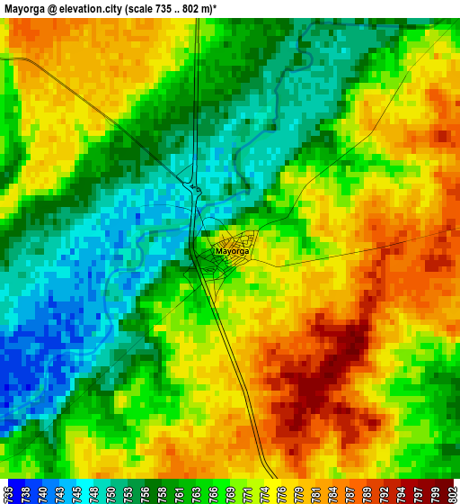
Below is the Elevation map of Mayorga, which displays elevation range with different colors. Scale of the first map is from 735 to 802 m (2411 to 2631 ft) with average elevation of 767.7 meters (=2519 ft) [note 1]
These maps also provides idea of topography and contour of this city, they are displayed at different zoom levels. More info about maps, scale and edge coordinates you can find below images.
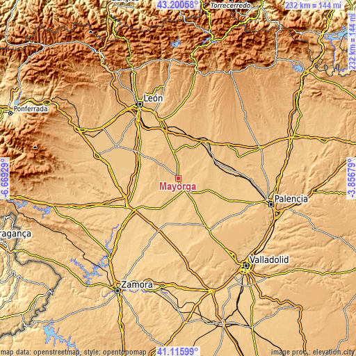
| \ | Map #1 | Topo.Map |
| Scale [m] | 735..802 m | × |
| Scale [ft] | 2411..2631 ft | × |
| Average | 767.7 m = 2519 ft | × |
| Width | 7.24 km = 4.5 mi | 231.8 km = 144 mi |
| Height | 7.24 km = 4.5 mi | 231.8 km = 144 mi |
| ↑Max Latitude | 42.199434° | 43.20058° |
| Latitude at center | 42.16687° | 42.16687° |
| ↓Min Latitude | 42.13429° | 41.11599° |
| ← Min Longitude | -5.306985° | -6.66929° |
| Longitude center | -5.26304° | -5.26304° |
| →Max Longitude | -5.219095° | -3.85679° |
Nearby cities:
Cities around Mayorga sort by population:
• Gordoncillo elevation 753 m
12 km,  253°
253°
• Becilla de Valderaduey 734 m
8.4 km,  153°
153°
• Villavicencio de los Caballeros 724 m
12.2 km,  169°
169°
• Izagre 785 m
6.4 km,  4°
4°
• Castroponce 740 m
8 km,  124°
124°
• Saelices de Mayorga 778 m
6.9 km,  43°
43°
• Urones de Castroponce 751 m
7.7 km,  191°
191°
• Monasterio de Vega 773 m
9.8 km, 43°
• Castrobol 771 m
5.4 km,  231°
231°
• Villagómez la Nueva 756 m
10 km,  96°
96°
• Cabezón de Valderaduey 762 m
8.6 km,  89°
89°
• Villalba de la Loma 773 m
6.1 km,  81°
81°
Multilingual:
 En español:
Mayorga elevación 780 m.
 En France:
Mayorga élévation 780 m.


Sources and notes:
- [note 1] Map square and city borders are not equal. Map elevation data is calculated only from area inside that square.
- [src 1] Elevation data from geonames database provided with same terms of usage.
- [src 2] The elevation map of Mayorga is generated using elevation data from NASA's 3 arcsec (90m) resolution SRTM data.
- [src 3] Base (background) map © OpenStreetMap contributors tiles are generated by Geofabrik and OpenTopoMap.
Copyright & License:
This Mayorga Elevation Map is licensed under CC BY-SA. You may reuse any part from this page, if you give a proper credit by linking to this URL:
 More info on terms of use page.