Valdepolo elevation
Valdepolo (Castille and León, Provincia de León), Spain elevation is 876 meters and Valdepolo elevation in feet is 2874 ft above sea level [src 1]. Valdepolo is a seat of a third-order administrative division (feature code) with elevation that is 273 meters (896 ft) bigger than average city elevation in Spain.
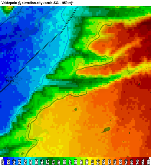
Below is the Elevation map of Valdepolo, which displays elevation range with different colors. Scale of the first map is from 833 to 959 m (2733 to 3146 ft) with average elevation of 895.1 meters (=2937 ft) [note 1]
These maps also provides idea of topography and contour of this city, they are displayed at different zoom levels. More info about maps, scale and edge coordinates you can find below images.
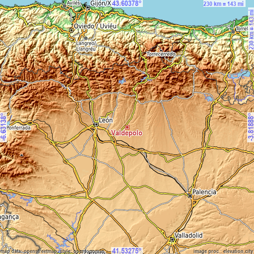
| \ | Map #1 | Topo.Map |
| Scale [m] | 833..959 m | × |
| Scale [ft] | 2733..3146 ft | × |
| Average | 895.1 m = 2937 ft | × |
| Width | 7.2 km = 4.5 mi | 230.3 km = 143.1 mi |
| Height | 7.2 km = 4.5 mi | 230.3 km = 143.1 mi |
| ↑Max Latitude | 42.609212° | 43.60378° |
| Latitude at center | 42.57686° | 42.57686° |
| ↓Min Latitude | 42.544492° | 41.53275° |
| ← Min Longitude | -5.269075° | -6.63138° |
| Longitude center | -5.22513° | -5.22513° |
| →Max Longitude | -5.181185° | -3.81888° |
Nearby cities:
Cities around Valdepolo sort by population:
• Mansilla de las Mulas elevation 802 m
18 km,  241°
241°
• Gradefes 854 m
5.2 km,  358°
358°
• Villasabariego 848 m
16.2 km,  252°
252°
• Santas Martas 838 m
20 km,  216°
216°
• Villazanzo de Valderaduey 915 m
21.8 km,  102°
102°
• Almanza 916 m
17.9 km,  59°
59°
• Cubillas de Rueda 885 m
9.7 km,  24°
24°
• Mansilla Mayor 793 m
19.3 km, 247°
• Santa María del Monte de Cea 886 m
13 km,  136°
136°
• Villamartín de Don Sancho 892 m
13.5 km,  93°
93°
• Villamoratiel de las Matas 848 m
20.9 km,  197°
197°
• Villaselán 864 m
14.6 km, 96°
Multilingual:
 En español:
Valdepolo elevación 876 m.
 En France:
Valdepolo élévation 876 m.
 Auf Deutsch:
Valdepolo höhe über dem Meeresspiegel ist 876 m.

Sources and notes:
- [note 1] Map square and city borders are not equal. Map elevation data is calculated only from area inside that square.
- [src 1] Elevation data from geonames database provided with same terms of usage.
- [src 2] The elevation map of Valdepolo is generated using elevation data from NASA's 3 arcsec (90m) resolution SRTM data.
- [src 3] Base (background) map © OpenStreetMap contributors tiles are generated by Geofabrik and OpenTopoMap.
Copyright & License:
This Valdepolo Elevation Map is licensed under CC BY-SA. You may reuse any part from this page, if you give a proper credit by linking to this URL:
 More info on terms of use page.