Villasabariego elevation
Villasabariego (Castille and León, Provincia de León), Spain elevation is 848 meters and Villasabariego elevation in feet is 2782 ft above sea level [src 1]. Villasabariego is a seat of a third-order administrative division (feature code) with elevation that is 245 meters (804 ft) bigger than average city elevation in Spain.
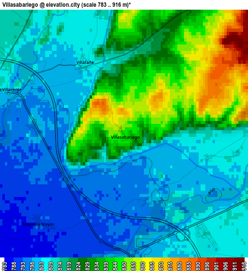
Below is the Elevation map of Villasabariego, which displays elevation range with different colors. Scale of the first map is from 783 to 916 m (2569 to 3005 ft) with average elevation of 816.5 meters (=2679 ft) [note 1]
These maps also provides idea of topography and contour of this city, they are displayed at different zoom levels. More info about maps, scale and edge coordinates you can find below images.
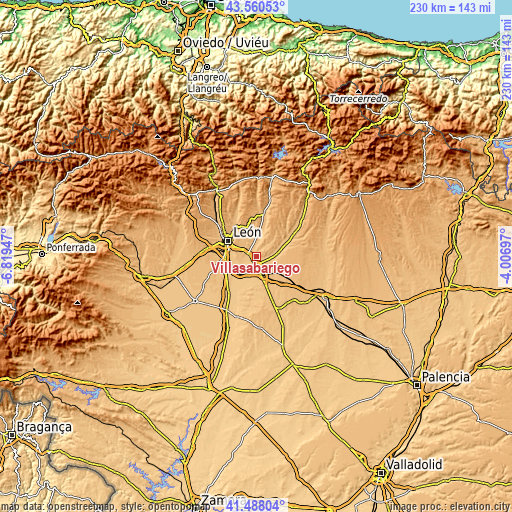
| \ | Map #1 | Topo.Map |
| Scale [m] | 783..916 m | × |
| Scale [ft] | 2569..3005 ft | × |
| Average | 816.5 m = 2679 ft | × |
| Width | 7.2 km = 4.5 mi | 230.4 km = 143.2 mi |
| Height | 7.2 km = 4.5 mi | 230.4 km = 143.2 mi |
| ↑Max Latitude | 42.565254° | 43.56053° |
| Latitude at center | 42.53288° | 42.53288° |
| ↓Min Latitude | 42.500489° | 41.48804° |
| ← Min Longitude | -5.457165° | -6.81947° |
| Longitude center | -5.41322° | -5.41322° |
| →Max Longitude | -5.369275° | -4.00697° |
Nearby cities:
Cities around Villasabariego sort by population:
• León elevation 844 m
14.9 km,  300°
300°
• Valdefresno 872 m
9.5 km,  316°
316°
• Mansilla de las Mulas 802 m
3.8 km,  185°
185°
• Villaturiel 798 m
6.2 km,  254°
254°
• Onzonilla 808 m
13.8 km,  266°
266°
• Valdepolo 876 m
16.2 km,  72°
72°
• Santas Martas 838 m
11.7 km,  162°
162°
• Vega de Infanzones 780 m
11.4 km,  239°
239°
• Villanueva de las Manzanas 780 m
8.7 km,  219°
219°
• Mansilla Mayor 793 m
3.6 km, 222°
• Campo de Villavidel 770 m
14.1 km, 222°
• Corbillos de los Oteros 791 m
14.4 km,  195°
195°
Multilingual:
 En español:
Villasabariego elevación 848 m.
 En France:
Villasabariego élévation 848 m.
 Auf Deutsch:
Villasabariego höhe über dem Meeresspiegel ist 848 m.

Sources and notes:
- [note 1] Map square and city borders are not equal. Map elevation data is calculated only from area inside that square.
- [src 1] Elevation data from geonames database provided with same terms of usage.
- [src 2] The elevation map of Villasabariego is generated using elevation data from NASA's 3 arcsec (90m) resolution SRTM data.
- [src 3] Base (background) map © OpenStreetMap contributors tiles are generated by Geofabrik and OpenTopoMap.
Copyright & License:
This Villasabariego Elevation Map is licensed under CC BY-SA. You may reuse any part from this page, if you give a proper credit by linking to this URL:
 More info on terms of use page.