Almanza elevation
Almanza (Castille and León, Provincia de León), Spain elevation is 916 meters and Almanza elevation in feet is 3005 ft above sea level [src 1]. Almanza is a seat of a third-order administrative division (feature code) with elevation that is 313 meters (1027 ft) bigger than average city elevation in Spain.
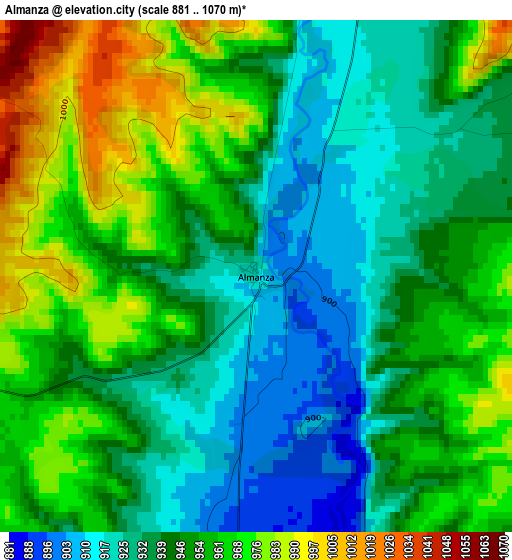
Below is the Elevation map of Almanza, which displays elevation range with different colors. Scale of the first map is from 881 to 1070 m (2890 to 3510 ft) with average elevation of 947.9 meters (=3110 ft) [note 1]
These maps also provides idea of topography and contour of this city, they are displayed at different zoom levels. More info about maps, scale and edge coordinates you can find below images.
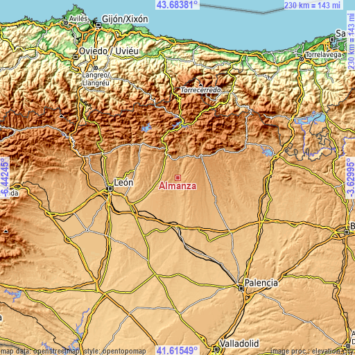
| \ | Map #1 | Topo.Map |
| Scale [m] | 881..1070 m | × |
| Scale [ft] | 2890..3510 ft | × |
| Average | 947.9 m = 3110 ft | × |
| Width | 7.19 km = 4.5 mi | 230 km = 142.9 mi |
| Height | 7.19 km = 4.5 mi | 230 km = 142.9 mi |
| ↑Max Latitude | 42.690559° | 43.68381° |
| Latitude at center | 42.65825° | 42.65825° |
| ↓Min Latitude | 42.625924° | 41.61549° |
| ← Min Longitude | -5.080145° | -6.44245° |
| Longitude center | -5.0362° | -5.0362° |
| →Max Longitude | -4.992255° | -3.62995° |
Nearby cities:
Cities around Almanza sort by population:
• Cistierna elevation 945 m
17.8 km,  335°
335°
• Valdepolo 876 m
17.9 km,  239°
239°
• Gradefes 854 m
16.1 km,  256°
256°
• Villazanzo de Valderaduey 915 m
14.8 km,  156°
156°
• Cubillas de Rueda 885 m
11.4 km,  268°
268°
• Pino del Río 996 m
18.7 km,  94°
94°
• Villalba de Guardo 1062 m
18.8 km,  67°
67°
• Cebanico 957 m
7.5 km,  6°
6°
• Villamartín de Don Sancho 892 m
10.1 km,  191°
191°
• Prado de la Guzpeña 1047 m
13.9 km,  3°
3°
• Fresno del Río 1016 m
18.1 km,  81°
81°
• Villaselán 864 m
10.9 km, 185°
Multilingual:
 En español:
Almanza elevación 916 m.
 En France:
Almanza élévation 916 m.


Sources and notes:
- [note 1] Map square and city borders are not equal. Map elevation data is calculated only from area inside that square.
- [src 1] Elevation data from geonames database provided with same terms of usage.
- [src 2] The elevation map of Almanza is generated using elevation data from NASA's 3 arcsec (90m) resolution SRTM data.
- [src 3] Base (background) map © OpenStreetMap contributors tiles are generated by Geofabrik and OpenTopoMap.
Copyright & License:
This Almanza Elevation Map is licensed under CC BY-SA. You may reuse any part from this page, if you give a proper credit by linking to this URL:
 More info on terms of use page.