Valseca elevation
Valseca (Castille and León, Provincia de Segovia), Spain elevation is 948 meters and Valseca elevation in feet is 3110 ft above sea level [src 1]. Valseca is a seat of a third-order administrative division (feature code) with elevation that is 345 meters (1132 ft) bigger than average city elevation in Spain.
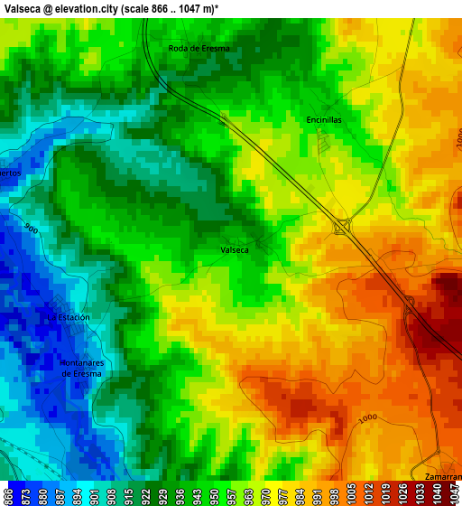
Below is the Elevation map of Valseca, which displays elevation range with different colors. Scale of the first map is from 866 to 1047 m (2841 to 3435 ft) with average elevation of 951.4 meters (=3121 ft) [note 1]
These maps also provides idea of topography and contour of this city, they are displayed at different zoom levels. More info about maps, scale and edge coordinates you can find below images.
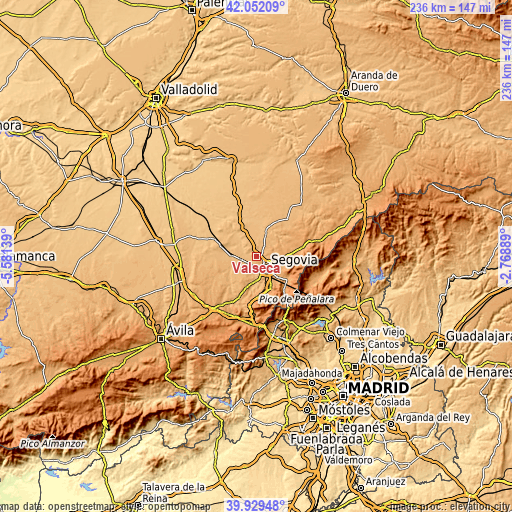
| \ | Map #1 | Topo.Map |
| Scale [m] | 866..1047 m | × |
| Scale [ft] | 2841..3435 ft | × |
| Average | 951.4 m = 3121 ft | × |
| Width | 7.38 km = 4.6 mi | 236 km = 146.6 mi |
| Height | 7.38 km = 4.6 mi | 236 km = 146.6 mi |
| ↑Max Latitude | 41.032488° | 42.05209° |
| Latitude at center | 40.99933° | 40.99933° |
| ↓Min Latitude | 40.966155° | 39.92948° |
| ← Min Longitude | -4.219085° | -5.58139° |
| Longitude center | -4.17514° | -4.17514° |
| →Max Longitude | -4.131195° | -2.76889° |
Nearby cities:
Cities around Valseca sort by population:
• Segovia elevation 996 m
7.4 km,  140°
140°
• La Lastrilla 1059 m
6.9 km,  120°
120°
• Cantimpalos 911 m
8.4 km,  8°
8°
• Valverde del Majano 925 m
6.9 km,  226°
226°
• Espirdo 1069 m
8.5 km,  91°
91°
• Garcillán 917 m
8 km,  252°
252°
• Hontanares de Eresma 880 m
3.1 km, 233°
• Yanguas de Eresma 895 m
9.7 km,  326°
326°
• Martín Miguel 921 m
9.6 km,  237°
237°
• Roda de Eresma 939 m
3.3 km,  350°
350°
• Cabañas de Polendos 943 m
9.3 km,  36°
36°
• Encinillas 947 m
2.5 km,  34°
34°
Multilingual:
 En español:
Valseca elevación 948 m.
 En France:
Valseca élévation 948 m.


Sources and notes:
- [note 1] Map square and city borders are not equal. Map elevation data is calculated only from area inside that square.
- [src 1] Elevation data from geonames database provided with same terms of usage.
- [src 2] The elevation map of Valseca is generated using elevation data from NASA's 3 arcsec (90m) resolution SRTM data.
- [src 3] Base (background) map © OpenStreetMap contributors tiles are generated by Geofabrik and OpenTopoMap.
Copyright & License:
This Valseca Elevation Map is licensed under CC BY-SA. You may reuse any part from this page, if you give a proper credit by linking to this URL:
 More info on terms of use page.