Espirdo elevation
Espirdo (Castille and León, Provincia de Segovia), Spain elevation is 1069 meters and Espirdo elevation in feet is 3507 ft above sea level [src 1]. Espirdo is a seat of a third-order administrative division (feature code) with elevation that is 466 meters (1529 ft) bigger than average city elevation in Spain.
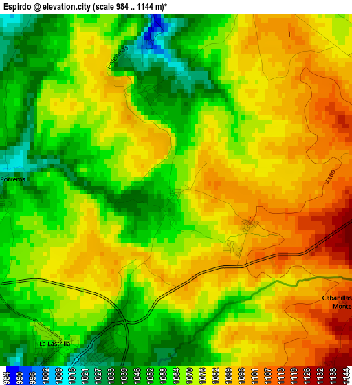
Below is the Elevation map of Espirdo, which displays elevation range with different colors. Scale of the first map is from 984 to 1144 m (3228 to 3753 ft) with average elevation of 1072.2 meters (=3518 ft) [note 1]
These maps also provides idea of topography and contour of this city, they are displayed at different zoom levels. More info about maps, scale and edge coordinates you can find below images.
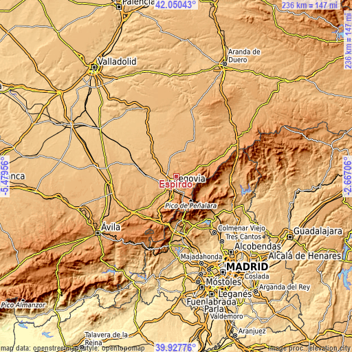
| \ | Map #1 | Topo.Map |
| Scale [m] | 984..1144 m | × |
| Scale [ft] | 3228..3753 ft | × |
| Average | 1072.2 m = 3518 ft | × |
| Width | 7.38 km = 4.6 mi | 236 km = 146.6 mi |
| Height | 7.38 km = 4.6 mi | 236 km = 146.6 mi |
| ↑Max Latitude | 41.030799° | 42.05043° |
| Latitude at center | 40.99764° | 40.99764° |
| ↓Min Latitude | 40.964465° | 39.92776° |
| ← Min Longitude | -4.117255° | -5.47956° |
| Longitude center | -4.07331° | -4.07331° |
| →Max Longitude | -4.029365° | -2.66706° |
Nearby cities:
Cities around Espirdo sort by population:
• Segovia elevation 996 m
6.7 km,  214°
214°
• Palazuelos de Eresma 1084 m
7.5 km,  171°
171°
• San Cristóbal de Segovia 1076 m
5.1 km,  183°
183°
• La Lastrilla 1059 m
4.2 km,  218°
218°
• Torrecaballeros 1160 m
4.1 km,  98°
98°
• Trescasas 1131 m
4.8 km,  139°
139°
• Basardilla 1094 m
5.2 km,  50°
50°
• Cabañas de Polendos 943 m
8.3 km,  338°
338°
• Encinillas 947 m
7.4 km,  287°
287°
• Brieva 1092 m
4.5 km,  21°
21°
• Santo Domingo de Pirón 1083 m
8.5 km,  55°
55°
• Adrada de Pirón 1022 m
6.4 km, 16°
Multilingual:
 En español:
Espirdo elevación 1069 m.
 En France:
Espirdo élévation 1069 m.
 Auf Deutsch:
Espirdo höhe über dem Meeresspiegel ist 1069 m.

Sources and notes:
- [note 1] Map square and city borders are not equal. Map elevation data is calculated only from area inside that square.
- [src 1] Elevation data from geonames database provided with same terms of usage.
- [src 2] The elevation map of Espirdo is generated using elevation data from NASA's 3 arcsec (90m) resolution SRTM data.
- [src 3] Base (background) map © OpenStreetMap contributors tiles are generated by Geofabrik and OpenTopoMap.
Copyright & License:
This Espirdo Elevation Map is licensed under CC BY-SA. You may reuse any part from this page, if you give a proper credit by linking to this URL:
 More info on terms of use page.