Cantimpalos elevation
Cantimpalos (Castille and León, Provincia de Segovia), Spain elevation is 911 meters and Cantimpalos elevation in feet is 2989 ft above sea level [src 1]. Cantimpalos is a seat of a third-order administrative division (feature code) with elevation that is 308 meters (1010 ft) bigger than average city elevation in Spain.
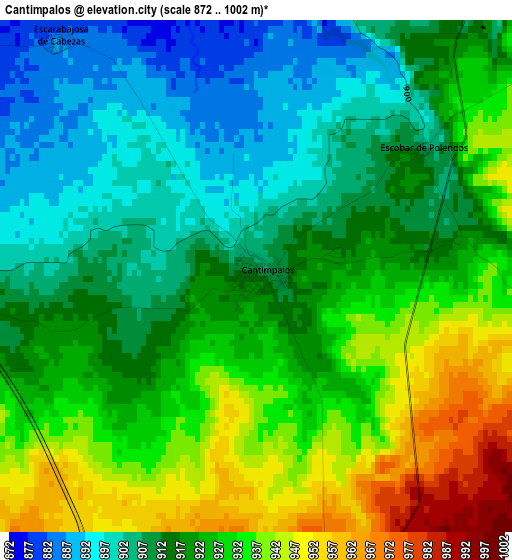
Below is the Elevation map of Cantimpalos, which displays elevation range with different colors. Scale of the first map is from 872 to 1002 m (2861 to 3287 ft) with average elevation of 920.5 meters (=3020 ft) [note 1]
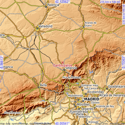
These maps also provides idea of topography and contour of this city, they are displayed at different zoom levels. More info about maps, scale and edge coordinates you can find below images.
| \ | Map #1 | Topo.Map |
| Scale [m] | 872..1002 m | × |
| Scale [ft] | 2861..3287 ft | × |
| Average | 920.5 m = 3020 ft | × |
| Width | 7.37 km = 4.6 mi | 235.7 km = 146.5 mi |
| Height | 7.37 km = 4.6 mi | 235.7 km = 146.5 mi |
| ↑Max Latitude | 41.10718° | 42.12562° |
| Latitude at center | 41.07406° | 41.07406° |
| ↓Min Latitude | 41.040923° | 40.00541° |
| ← Min Longitude | -4.203825° | -5.56613° |
| Longitude center | -4.15988° | -4.15988° |
| →Max Longitude | -4.115935° | -2.75363° |
Nearby cities:
Cities around Cantimpalos sort by population:
• Carbonero el Mayor elevation 915 m
10.3 km,  301°
301°
• Mozoncillo 860 m
8.3 km,  343°
343°
• Escarabajosa de Cabezas 883 m
4.5 km,  319°
319°
• Valseca 948 m
8.4 km,  188°
188°
• Escobar de Polendos 906 m
3 km,  52°
52°
• Yanguas de Eresma 895 m
6.6 km,  268°
268°
• Roda de Eresma 939 m
5.4 km,  199°
199°
• Cabañas de Polendos 943 m
4.3 km,  101°
101°
• Encinillas 947 m
6.2 km,  178°
178°
• Tabanera la Luenga 906 m
7.1 km,  290°
290°
• Brieva 1092 m
9.9 km,  116°
116°
• Adrada de Pirón 1022 m
9.4 km, 104°
Multilingual:
 En español:
Cantimpalos elevación 911 m.
 En France:
Cantimpalos élévation 911 m.
 Auf Deutsch:
Cantimpalos höhe über dem Meeresspiegel ist 911 m.

Sources and notes:
- [note 1] Map square and city borders are not equal. Map elevation data is calculated only from area inside that square.
- [src 1] Elevation data from geonames database provided with same terms of usage.
- [src 2] The elevation map of Cantimpalos is generated using elevation data from NASA's 3 arcsec (90m) resolution SRTM data.
- [src 3] Base (background) map © OpenStreetMap contributors tiles are generated by Geofabrik and OpenTopoMap.
Copyright & License:
This Cantimpalos Elevation Map is licensed under CC BY-SA. You may reuse any part from this page, if you give a proper credit by linking to this URL:
 More info on terms of use page.