Adra elevation
Adra (Andalusia, Almería), Spain elevation is 28 meters and Adra elevation in feet is 92 ft above sea level [src 1]. Adra is a seat of a third-order administrative division (feature code) with elevation that is 575 meters (1886 ft) smaller than average city elevation in Spain.
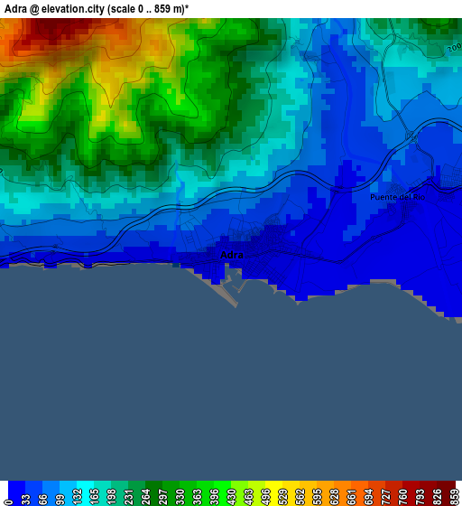
Below is the Elevation map of Adra, which displays elevation range with different colors. Scale of the first map is from 0 to 859 m (0 to 2818 ft) with average elevation of 190.7 meters (=626 ft) [note 1]
These maps also provides idea of topography and contour of this city, they are displayed at different zoom levels. More info about maps, scale and edge coordinates you can find below images.
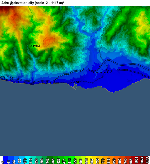
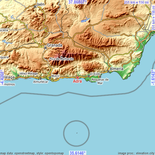
| \ | Map #1 | Map #2 | Topo.Map |
| Scale [m] | 0..859 m | -2..1117 m | × |
| Scale [ft] | 0..2818 ft | -7..3665 ft | × |
| Average | 190.7 m = 626 ft | 329 m = 1079 ft | × |
| Width | 7.83 km = 4.9 mi | 15.66 km = 9.7 mi | 250.6 km = 155.7 mi |
| Height | 7.83 km = 4.9 mi | 15.66 km = 9.7 mi | 250.6 km = 155.7 mi |
| ↑Max Latitude | 36.784813° | 36.820001° | 37.86807° |
| Latitude at center | 36.74961° | 36.74961° | 36.74961° |
| ↓Min Latitude | 36.71439° | 36.679155° | 35.6146° |
| ← Min Longitude | -3.064495° | -3.108441° | -4.4268° |
| Longitude center | -3.02055° | -3.02055° | -3.02055° |
| →Max Longitude | -2.976605° | -2.932659° | -1.6143° |
Nearby cities:
Cities around Adra sort by population:
• El Ejido elevation 84 m
18.6 km,  80°
80°
• Berja 338 m
12.5 km,  30°
30°
• Albuñol 259 m
17.1 km,  286°
286°
• Dalías 422 m
15.5 km,  58°
58°
• Ugíjar 548 m
23.7 km,  352°
352°
• Polopos 794 m
25.2 km,  281°
281°
• Cádiar 930 m
26 km,  326°
326°
• Alcolea 741 m
25.6 km,  11°
11°
• Albondón 924 m
19.1 km,  297°
297°
• Sorvilán 790 m
22.6 km, 282°
• Murtas 1124 m
17 km, 332°
• Balanegra 15 m
9.9 km,  90°
90°
Multilingual:
 En español:
Adra elevación 28 m.
 En France:
Adra élévation 28 m.


Sources and notes:
- [note 1] Map square and city borders are not equal. Map elevation data is calculated only from area inside that square.
- [src 1] Elevation data from geonames database provided with same terms of usage.
- [src 2] The elevation map of Adra is generated using elevation data from NASA's 3 arcsec (90m) resolution SRTM data.
- [src 3] Base (background) map © OpenStreetMap contributors tiles are generated by Geofabrik and OpenTopoMap.
Copyright & License:
This Adra Elevation Map is licensed under CC BY-SA. You may reuse any part from this page, if you give a proper credit by linking to this URL:
 More info on terms of use page.