Albuñol elevation
Albuñol (Andalusia, Provincia de Granada), Spain elevation is 259 meters and Albuñol elevation in feet is 850 ft above sea level [src 1]. Albuñol is a seat of a third-order administrative division (feature code) with elevation that is 344 meters (1129 ft) smaller than average city elevation in Spain.
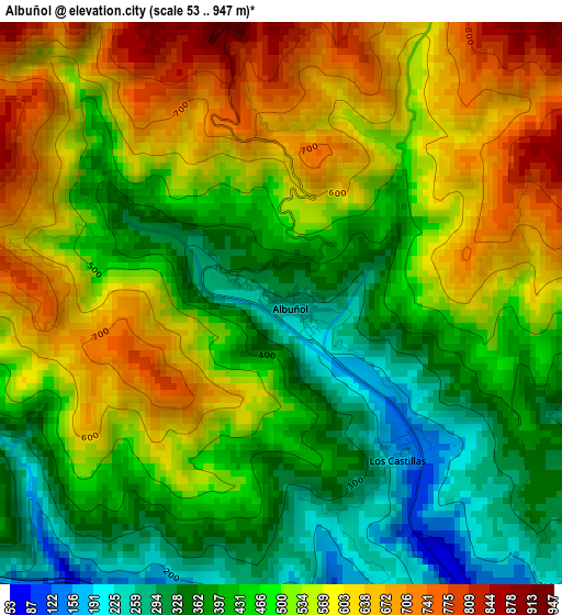
Below is the Elevation map of Albuñol, which displays elevation range with different colors. Scale of the first map is from 53 to 947 m (174 to 3107 ft) with average elevation of 491.9 meters (=1614 ft) [note 1]
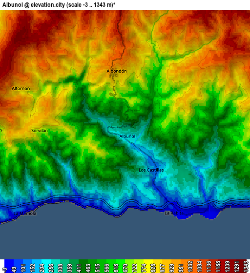
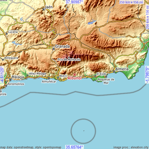
These maps also provides idea of topography and contour of this city, they are displayed at different zoom levels. More info about maps, scale and edge coordinates you can find below images.
| \ | Map #1 | Map #2 | Topo.Map |
| Scale [m] | 53..947 m | -3..1343 m | × |
| Scale [ft] | 174..3107 ft | -10..4406 ft | × |
| Average | 491.9 m = 1614 ft | 662.8 m = 2175 ft | × |
| Width | 7.83 km = 4.9 mi | 15.65 km = 9.7 mi | 250.4 km = 155.6 mi |
| Height | 7.83 km = 4.9 mi | 15.65 km = 9.7 mi | 250.4 km = 155.6 mi |
| ↑Max Latitude | 36.827214° | 36.862382° | 37.90987° |
| Latitude at center | 36.79203° | 36.79203° | 36.79203° |
| ↓Min Latitude | 36.75683° | 36.721614° | 35.65764° |
| ← Min Longitude | -3.248945° | -3.292891° | -4.61125° |
| Longitude center | -3.205° | -3.205° | -3.205° |
| →Max Longitude | -3.161055° | -3.117109° | -1.79875° |
Nearby cities:
Cities around Albuñol sort by population:
• Adra elevation 28 m
17.1 km,  106°
106°
• Castell de Ferro 21 m
15.3 km,  241°
241°
• Gualchos 355 m
17.4 km,  252°
252°
• Polopos 794 m
8.3 km,  272°
272°
• Cádiar 930 m
17.3 km,  7°
7°
• Albondón 924 m
4 km,  351°
351°
• Sorvilán 790 m
5.6 km, 273°
• Murtas 1124 m
13.4 km,  39°
39°
• Rubite 791 m
12.9 km,  278°
278°
• Almegíjar 818 m
15 km,  325°
325°
• Cástaras 1022 m
16.1 km,  344°
344°
• Lobras 927 m
15.2 km,  357°
357°
Multilingual:
 En español:
Albuñol elevación 259 m.
 En France:
Albuñol élévation 259 m.


Sources and notes:
- [note 1] Map square and city borders are not equal. Map elevation data is calculated only from area inside that square.
- [src 1] Elevation data from geonames database provided with same terms of usage.
- [src 2] The elevation map of Albuñol is generated using elevation data from NASA's 3 arcsec (90m) resolution SRTM data.
- [src 3] Base (background) map © OpenStreetMap contributors tiles are generated by Geofabrik and OpenTopoMap.
Copyright & License:
This Albuñol Elevation Map is licensed under CC BY-SA. You may reuse any part from this page, if you give a proper credit by linking to this URL:
 More info on terms of use page.