Dalías elevation
Dalías (Andalusia, Almería), Spain elevation is 422 meters and Dalías elevation in feet is 1385 ft above sea level [src 1]. Dalías is a populated place (feature code) with elevation that is 181 meters (594 ft) smaller than average city elevation in Spain.
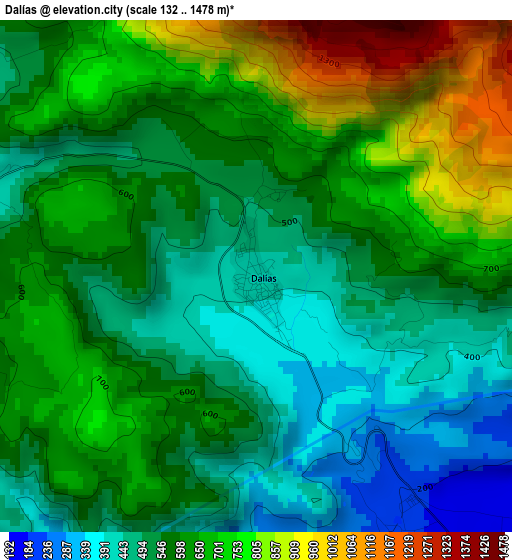
Below is the Elevation map of Dalías, which displays elevation range with different colors. Scale of the first map is from 132 to 1478 m (433 to 4849 ft) with average elevation of 599 meters (=1965 ft) [note 1]
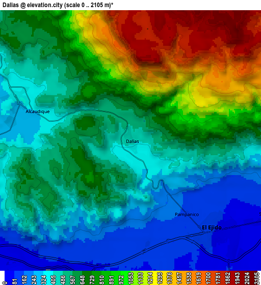
These maps also provides idea of topography and contour of this city, they are displayed at different zoom levels. More info about maps, scale and edge coordinates you can find below images.
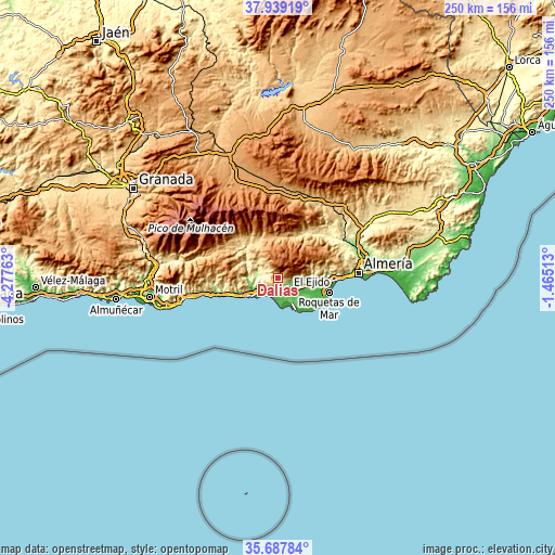
| \ | Map #1 | Map #2 | Topo.Map |
| Scale [m] | 132..1478 m | 0..2105 m | × |
| Scale [ft] | 433..4849 ft | 0..6906 ft | × |
| Average | 599 m = 1965 ft | 671.8 m = 2204 ft | × |
| Width | 7.82 km = 4.9 mi | 15.65 km = 9.7 mi | 250.3 km = 155.5 mi |
| Height | 7.82 km = 4.9 mi | 15.65 km = 9.7 mi | 250.3 km = 155.5 mi |
| ↑Max Latitude | 36.85696° | 36.892114° | 37.93919° |
| Latitude at center | 36.82179° | 36.82179° | 36.82179° |
| ↓Min Latitude | 36.786604° | 36.751401° | 35.68784° |
| ← Min Longitude | -2.915325° | -2.959271° | -4.27763° |
| Longitude center | -2.87138° | -2.87138° | -2.87138° |
| →Max Longitude | -2.827435° | -2.783489° | -1.46513° |
Nearby cities:
Cities around Dalías sort by population:
• El Ejido elevation 84 m
7.2 km,  135°
135°
• Adra 28 m
15.5 km,  238°
238°
• Vícar 278 m
20.4 km,  86°
86°
• Berja 338 m
7.5 km,  291°
291°
• La Gangosa Vistasol 88 m
22.3 km, 94°
• Laujar de Andarax 932 m
19.4 km,  355°
355°
• Alcolea 741 m
18.8 km,  334°
334°
• Fondón 851 m
17.6 km,  3°
3°
• Murtas 1124 m
22.3 km, 288°
• Padules 748 m
21.4 km,  23°
23°
• Almócita 832 m
21.4 km, 19°
• Balanegra 15 m
8.8 km,  202°
202°
Multilingual:
 En español:
Dalías elevación 422 m.
 En France:
Dalías élévation 422 m.


Sources and notes:
- [note 1] Map square and city borders are not equal. Map elevation data is calculated only from area inside that square.
- [src 1] Elevation data from geonames database provided with same terms of usage.
- [src 2] The elevation map of Dalías is generated using elevation data from NASA's 3 arcsec (90m) resolution SRTM data.
- [src 3] Base (background) map © OpenStreetMap contributors tiles are generated by Geofabrik and OpenTopoMap.
Copyright & License:
This Dalías Elevation Map is licensed under CC BY-SA. You may reuse any part from this page, if you give a proper credit by linking to this URL:
 More info on terms of use page.