Berja elevation
Berja (Andalusia, Almería), Spain elevation is 338 meters and Berja elevation in feet is 1109 ft above sea level [src 1]. Berja is a seat of a third-order administrative division (feature code) with elevation that is 265 meters (869 ft) smaller than average city elevation in Spain.
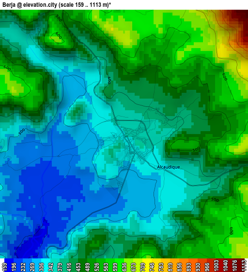
Below is the Elevation map of Berja, which displays elevation range with different colors. Scale of the first map is from 159 to 1113 m (522 to 3652 ft) with average elevation of 427.6 meters (=1403 ft) [note 1]
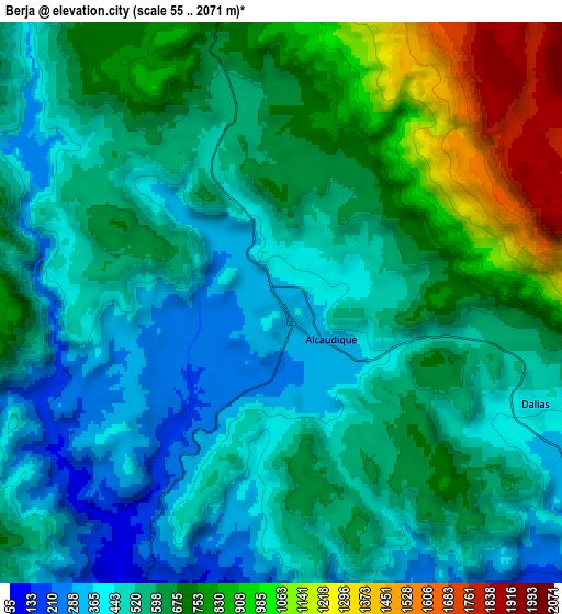
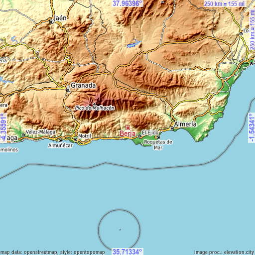
These maps also provides idea of topography and contour of this city, they are displayed at different zoom levels. More info about maps, scale and edge coordinates you can find below images.
| \ | Map #1 | Map #2 | Topo.Map |
| Scale [m] | 159..1113 m | 55..2071 m | × |
| Scale [ft] | 522..3652 ft | 180..6795 ft | × |
| Average | 427.6 m = 1403 ft | 609.6 m = 2000 ft | × |
| Width | 7.82 km = 4.9 mi | 15.64 km = 9.7 mi | 250.2 km = 155.5 mi |
| Height | 7.82 km = 4.9 mi | 15.64 km = 9.7 mi | 250.2 km = 155.5 mi |
| ↑Max Latitude | 36.882089° | 36.917231° | 37.96396° |
| Latitude at center | 36.84693° | 36.84693° | 36.84693° |
| ↓Min Latitude | 36.811755° | 36.776564° | 35.71334° |
| ← Min Longitude | -2.993605° | -3.037551° | -4.35591° |
| Longitude center | -2.94966° | -2.94966° | -2.94966° |
| →Max Longitude | -2.905715° | -2.861769° | -1.54341° |
Nearby cities:
Cities around Berja sort by population:
• El Ejido elevation 84 m
14.4 km,  123°
123°
• Adra 28 m
12.5 km,  210°
210°
• Dalías 422 m
7.5 km,  111°
111°
• Ugíjar 548 m
15.8 km,  323°
323°
• Laujar de Andarax 932 m
17.3 km,  17°
17°
• Alcolea 741 m
14.2 km,  355°
355°
• Fondón 851 m
16.8 km,  28°
28°
• Válor 896 m
20.4 km, 324°
• Murtas 1124 m
14.8 km,  286°
286°
• Paterna del Río 1209 m
19.5 km, 359°
• Bayárcal 1267 m
20.8 km,  348°
348°
• Balanegra 15 m
11.5 km,  161°
161°
Multilingual:
 En español:
Berja elevación 338 m.
 En France:
Berja élévation 338 m.


Sources and notes:
- [note 1] Map square and city borders are not equal. Map elevation data is calculated only from area inside that square.
- [src 1] Elevation data from geonames database provided with same terms of usage.
- [src 2] The elevation map of Berja is generated using elevation data from NASA's 3 arcsec (90m) resolution SRTM data.
- [src 3] Base (background) map © OpenStreetMap contributors tiles are generated by Geofabrik and OpenTopoMap.
Copyright & License:
This Berja Elevation Map is licensed under CC BY-SA. You may reuse any part from this page, if you give a proper credit by linking to this URL:
 More info on terms of use page.