Albatana elevation
Albatana (Castille-La Mancha, Provincia de Albacete), Spain elevation is 584 meters and Albatana elevation in feet is 1916 ft above sea level [src 1]. Albatana is a seat of a third-order administrative division (feature code) with elevation that is 19 meters (62 ft) smaller than average city elevation in Spain.
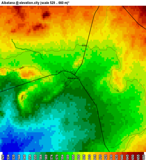
Below is the Elevation map of Albatana, which displays elevation range with different colors. Scale of the first map is from 529 to 660 m (1736 to 2165 ft) with average elevation of 592 meters (=1942 ft) [note 1]
These maps also provides idea of topography and contour of this city, they are displayed at different zoom levels. More info about maps, scale and edge coordinates you can find below images.
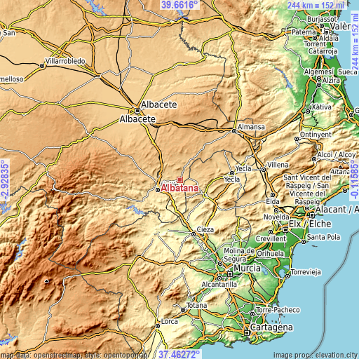
| \ | Map #1 | Topo.Map |
| Scale [m] | 529..660 m | × |
| Scale [ft] | 1736..2165 ft | × |
| Average | 592 m = 1942 ft | × |
| Width | 7.64 km = 4.7 mi | 244.5 km = 151.9 mi |
| Height | 7.64 km = 4.7 mi | 244.5 km = 151.9 mi |
| ↑Max Latitude | 38.60492° | 39.6616° |
| Latitude at center | 38.57057° | 38.57057° |
| ↓Min Latitude | 38.536204° | 37.46272° |
| ← Min Longitude | -1.566045° | -2.92835° |
| Longitude center | -1.5221° | -1.5221° |
| →Max Longitude | -1.478155° | -0.11585° |
Nearby cities:
Cities around Albatana sort by population:
• Yecla elevation 620 m
35.7 km,  82°
82°
• Hellín 557 m
16.9 km,  246°
246°
• Jumilla 527 m
19.9 km,  120°
120°
• Tobarra 650 m
15 km,  279°
279°
• Fuente-Álamo 825 m
15.7 km,  30°
30°
• Pozo-Cañada 811 m
31.8 km,  324°
324°
• Ontur 662 m
5.4 km,  23°
23°
• Montealegre del Castillo 803 m
29.6 km, 34°
• Liétor 672 m
37.7 km,  265°
265°
• Bonete 894 m
36.7 km, 24°
• Pétrola 870 m
28.6 km,  353°
353°
• Corral-Rubio 875 m
29.8 km,  10°
10°
Multilingual:
 En español:
Albatana elevación 584 m.
 En France:
Albatana élévation 584 m.
 Auf Deutsch:
Albatana höhe über dem Meeresspiegel ist 584 m.

Sources and notes:
- [note 1] Map square and city borders are not equal. Map elevation data is calculated only from area inside that square.
- [src 1] Elevation data from geonames database provided with same terms of usage.
- [src 2] The elevation map of Albatana is generated using elevation data from NASA's 3 arcsec (90m) resolution SRTM data.
- [src 3] Base (background) map © OpenStreetMap contributors tiles are generated by Geofabrik and OpenTopoMap.
Copyright & License:
This Albatana Elevation Map is licensed under CC BY-SA. You may reuse any part from this page, if you give a proper credit by linking to this URL:
 More info on terms of use page.