Yecla elevation
Yecla (Murcia), Spain elevation is 620 meters and Yecla elevation in feet is 2034 ft above sea level [src 1]. Yecla is a seat of a third-order administrative division (feature code) with elevation that is 17 meters (56 ft) bigger than average city elevation in Spain.
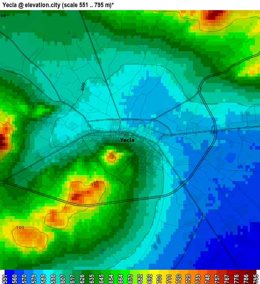
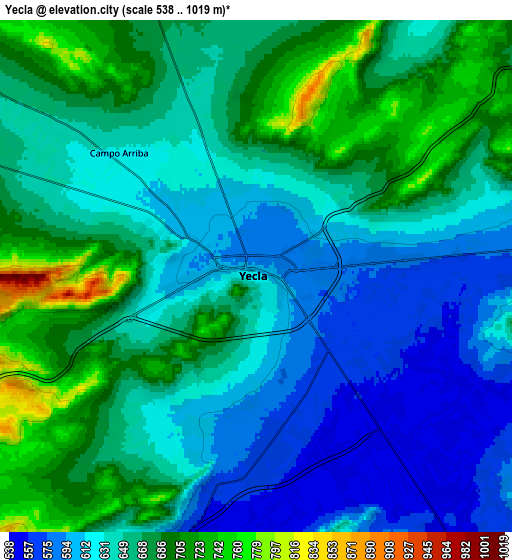
Below is the Elevation map of Yecla, which displays elevation range with different colors. Scale of the first map is from 551 to 795 m (1808 to 2608 ft) with average elevation of 617.9 meters (=2027 ft) [note 1]
These maps also provides idea of topography and contour of this city, they are displayed at different zoom levels. More info about maps, scale and edge coordinates you can find below images.
| \ | Map #1 | Map #2 | Topo.Map |
| Scale [m] | 551..795 m | 538..1019 m | × |
| Scale [ft] | 1808..2608 ft | 1765..3343 ft | × |
| Average | 617.9 m = 2027 ft | 648.5 m = 2128 ft | × |
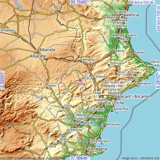
| Width | 7.64 km = 4.7 mi | 15.27 km = 9.5 mi | 244.3 km = 151.8 mi |
| Height | 7.64 km = 4.7 mi | 15.27 km = 9.5 mi | 244.3 km = 151.8 mi |
| ↑Max Latitude | 38.647979° | 38.682292° | 39.70402° |
| Latitude at center | 38.61365° | 38.61365° | 38.61365° |
| ↓Min Latitude | 38.579304° | 38.544942° | 37.50646° |
| ← Min Longitude | -1.158625° | -1.202571° | -2.52093° |
| Longitude center | -1.11468° | -1.11468° | -1.11468° |
| →Max Longitude | -1.070735° | -1.026789° | 0.29157° |
Nearby cities:
Cities around Yecla sort by population:
• Villena elevation 525 m
21.8 km,  83°
83°
• Almansa 702 m
28.5 km,  3°
3°
• Jumilla 527 m
23.6 km,  230°
230°
• Caudete 556 m
15.2 km,  46°
46°
• Sax 480 m
27.2 km,  108°
108°
• Pinoso 573 m
24.4 km,  164°
164°
• Biar 723 m
30.5 km,  86°
86°
• Fuente-Álamo 825 m
28.9 km,  287°
287°
• Montealegre del Castillo 803 m
26.8 km,  316°
316°
• La Font de la Figuera 588 m
28.8 km,  44°
44°
• Salinas 491 m
20.5 km,  120°
120°
• Cañada 561 m
27 km, 75°
Multilingual:
 En español:
Yecla elevación 620 m.
 En France:
Yecla élévation 620 m.


Sources and notes:
- [note 1] Map square and city borders are not equal. Map elevation data is calculated only from area inside that square.
- [src 1] Elevation data from geonames database provided with same terms of usage.
- [src 2] The elevation map of Yecla is generated using elevation data from NASA's 3 arcsec (90m) resolution SRTM data.
- [src 3] Base (background) map © OpenStreetMap contributors tiles are generated by Geofabrik and OpenTopoMap.
Copyright & License:
This Yecla Elevation Map is licensed under CC BY-SA. You may reuse any part from this page, if you give a proper credit by linking to this URL:
 More info on terms of use page.